IMAGES TAKEN NEAR TO
Rhosesmor, MOLD, CH7 6PE
Introduction
This page details the photographs taken nearby to CH7 6PE by members of the Geograph project.
The Geograph project started in 2005 with the aim of publishing, organising and preserving representative images for every square kilometre of Great Britain, Ireland and the Isle of Man.

There are currently over 7.5m images from over14,400 individuals and you can help contribute to the project by visiting https://www.geograph.org.uk
Image Map
Images are licensed for reuse under creativecommons.org/licenses/by-sa/2.0
Notes
- Clicking on the map will re-center to the selected point.
- The higher the marker number, the further away the image location is from the centre of the postcode.
Image Listing (5 Images Found)
Images are licensed for reuse under creativecommons.org/licenses/by-sa/2.0
Image
Details
Distance
1
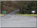
Keepers Cottage
Road entrance to Bryn-gelli, just off the B5123.
Image: © J Scott
Taken: 11 Jan 2011
0.06 miles
2
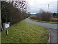
Exit left
Keepers cottage track junction with minor road leading to the B5123.
Image: © J Scott
Taken: 11 Jan 2011
0.08 miles
3
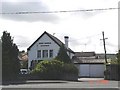
Post office at Rhydymwyn
The post office in the small village of Rhydymwyn on the main Mold - Denbigh road
Image: © Dot Potter
Taken: 14 Aug 2005
0.18 miles
4
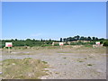
Rhosesmor Sand and Gravel Pit
Now disused; on the B1523 near Rhydymwyn.
Image: © Eirian Evans
Taken: 17 Jul 2006
0.19 miles
5
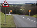
Cow corner
The B5123 approaches junction with the A541.
Image: © J Scott
Taken: 11 Jan 2011
0.25 miles