IMAGES TAKEN NEAR TO
Allt Goch Lane, MOLD, CH7 6DL
Introduction
This page details the photographs taken nearby to Allt Goch Lane, CH7 6DL by members of the Geograph project.
The Geograph project started in 2005 with the aim of publishing, organising and preserving representative images for every square kilometre of Great Britain, Ireland and the Isle of Man.

There are currently over 7.5m images from over14,400 individuals and you can help contribute to the project by visiting https://www.geograph.org.uk
Image Map
Images are licensed for reuse under creativecommons.org/licenses/by-sa/2.0
Notes
- Clicking on the map will re-center to the selected point.
- The higher the marker number, the further away the image location is from the centre of the postcode.
Image Listing (3 Images Found)
Images are licensed for reuse under creativecommons.org/licenses/by-sa/2.0
Image
Details
Distance
1
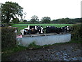
All at the trough
In a field north of Bryn Mawr Farm
Image: © Maggie Cox
Taken: 26 Oct 2013
0.13 miles
2
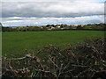
Across fields towards Bryn Bach
Bryn Mawr Farm on the right and in the far distance on the left, the Dee Estuary and the Wirral can just be seen from here
Image: © Maggie Cox
Taken: 26 Oct 2013
0.14 miles
3
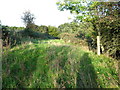
Footpath through small area of scrub and woodland
Near Bryn Bach
Image: © Maggie Cox
Taken: 26 Oct 2013
0.22 miles