IMAGES TAKEN NEAR TO
Mold Road, MOLD, CH7 6BX
Introduction
This page details the photographs taken nearby to Mold Road, CH7 6BX by members of the Geograph project.
The Geograph project started in 2005 with the aim of publishing, organising and preserving representative images for every square kilometre of Great Britain, Ireland and the Isle of Man.

There are currently over 7.5m images from over14,400 individuals and you can help contribute to the project by visiting https://www.geograph.org.uk
Image Map
Images are licensed for reuse under creativecommons.org/licenses/by-sa/2.0
Notes
- Clicking on the map will re-center to the selected point.
- The higher the marker number, the further away the image location is from the centre of the postcode.
Image Listing (4 Images Found)
Images are licensed for reuse under creativecommons.org/licenses/by-sa/2.0
Image
Details
Distance
1
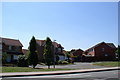
Housing Estate, Connah's Quay
New houses on the Mold Road, west Connah's Quay.
Image: © Eirian Evans
Taken: 17 Jul 2006
0.12 miles
3
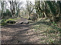
Broadoak Wood, Connah's Quay
Woodland in the western part of Connah's Quay, classed as "ancient semi-natural woodland", which have been here from at least the middle ages. They probably formed part of Ewloe Wood which Edward the Black Prince used for deer hunting in the 14th century.
Image: © Eirian Evans
Taken: 1 Mar 2008
0.23 miles
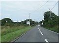
4
The B5126 Mold Road and a damaged milestone
Looking across the B5126 Mold Road. There is a badly damaged milestone on the edge of the road/grass verge towards the right of the photo - Image
Image: © John S Turner
Taken: 16 May 2019
0.24 miles