IMAGES TAKEN NEAR TO
Bryn Eithin Road, MOLD, CH7 5UU
Introduction
This page details the photographs taken nearby to Bryn Eithin Road, CH7 5UU by members of the Geograph project.
The Geograph project started in 2005 with the aim of publishing, organising and preserving representative images for every square kilometre of Great Britain, Ireland and the Isle of Man.

There are currently over 7.5m images from over14,400 individuals and you can help contribute to the project by visiting https://www.geograph.org.uk
Image Map
Images are licensed for reuse under creativecommons.org/licenses/by-sa/2.0
Notes
- Clicking on the map will re-center to the selected point.
- The higher the marker number, the further away the image location is from the centre of the postcode.
Image Listing (6 Images Found)
Images are licensed for reuse under creativecommons.org/licenses/by-sa/2.0
Image
Details
Distance
1
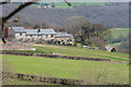
Coed-mynydd-isaf Farm
Farm houses to rear of Gwenoldy.
Image: © J Scott
Taken: 16 Apr 2010
0.01 miles
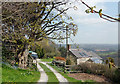
5
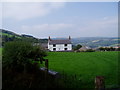
Bryn yr Eithin Farm
Farm with fantastic views - north up to Liverpool Bay, south to the Clwydian hills.
Image: © Eirian Evans
Taken: 16 Sep 2006
0.25 miles
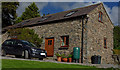
6
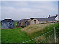
Bryn yr Eithin Farm
Farm buildings at Bryn yr Eithin Farm.
Image: © Eirian Evans
Taken: 16 Sep 2006
0.25 miles