IMAGES TAKEN NEAR TO
Afonwen, MOLD, CH7 5UN
Introduction
This page details the photographs taken nearby to CH7 5UN by members of the Geograph project.
The Geograph project started in 2005 with the aim of publishing, organising and preserving representative images for every square kilometre of Great Britain, Ireland and the Isle of Man.

There are currently over 7.5m images from over14,400 individuals and you can help contribute to the project by visiting https://www.geograph.org.uk
Image Map
Images are licensed for reuse under creativecommons.org/licenses/by-sa/2.0
Notes
- Clicking on the map will re-center to the selected point.
- The higher the marker number, the further away the image location is from the centre of the postcode.
Image Listing (2 Images Found)
Images are licensed for reuse under creativecommons.org/licenses/by-sa/2.0
Image
Details
Distance
1
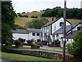
Craft centre and Afon Chwiler at Afonwen
The craft centre housed in converted barns and former farm buildings with the Afon Chwiler crossing the foreground
Image: © Dot Potter
Taken: 25 Jul 2005
0.20 miles
2
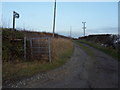
Llwybr Ceffyl
Public bridleway number 46 off minor road to Babell, leading to Ysceifiog.
Image: © J Scott
Taken: 17 Feb 2011
0.24 miles