IMAGES TAKEN NEAR TO
Llanarmon-Yn-Ial, MOLD, CH7 5TQ
Introduction
This page details the photographs taken nearby to CH7 5TQ by members of the Geograph project.
The Geograph project started in 2005 with the aim of publishing, organising and preserving representative images for every square kilometre of Great Britain, Ireland and the Isle of Man.

There are currently over 7.5m images from over14,400 individuals and you can help contribute to the project by visiting https://www.geograph.org.uk
Image Map
Images are licensed for reuse under creativecommons.org/licenses/by-sa/2.0
Notes
- Clicking on the map will re-center to the selected point.
- The higher the marker number, the further away the image location is from the centre of the postcode.
Image Listing (3 Images Found)
Images are licensed for reuse under creativecommons.org/licenses/by-sa/2.0
Image
Details
Distance
1

NOT an early JCB
A redundant grass cutter built by Henry Bamford & Sons of Uttoxeter. The UK workshop of Henry Bamford finally went into liquidation in 1987 having traded for 116 years, although they could still be operating in Eire and South Africa. The first Henry Bamford was the great grandfather of the more famous Joseph Cyril Bamford of Rocester (JCB), who created his own very successful business.
The gulf of the disused Pistyll Gwyn quarry can be seen over the fence.
(Thanks to Jonathan Kington for the corrected information.)
Image: © John S Turner
Taken: 28 Sep 2006
0.17 miles
2
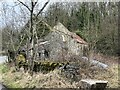
Abandoned and overgrown
Derelict buildings at the former Pystyll Gwyn quarry.
Image: © John H Darch
Taken: 4 Mar 2023
0.23 miles
3

Afon Alun
The river Alun, flowing north near Llanarmon yn Iâl.
Image: © Eirian Evans
Taken: 1 Jul 2006
0.23 miles