IMAGES TAKEN NEAR TO
Llanferres, MOLD, CH7 5ST
Introduction
This page details the photographs taken nearby to CH7 5ST by members of the Geograph project.
The Geograph project started in 2005 with the aim of publishing, organising and preserving representative images for every square kilometre of Great Britain, Ireland and the Isle of Man.

There are currently over 7.5m images from over14,400 individuals and you can help contribute to the project by visiting https://www.geograph.org.uk
Image Map
Images are licensed for reuse under creativecommons.org/licenses/by-sa/2.0
Notes
- Clicking on the map will re-center to the selected point.
- The higher the marker number, the further away the image location is from the centre of the postcode.
Image Listing (3 Images Found)
Images are licensed for reuse under creativecommons.org/licenses/by-sa/2.0
Image
Details
Distance
1
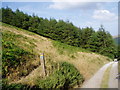
Small woodland near Plymog on Fron Hen
Image: © Eirian Evans
Taken: 26 Jul 2006
0.20 miles
2
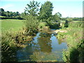
Afon Alun
Near Llanferres. A.k.a. River Alyn
Image: © David Medcalf
Taken: 8 Aug 2005
0.22 miles
3
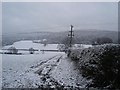
Footpath to Afon Alun
Footpath leading down to the Afon Alun
Image: © Dot Potter
Taken: Unknown
0.22 miles