IMAGES TAKEN NEAR TO
Bryn Eithin, Tafarn-y-Gelyn, MOLD, CH7 5SJ
Introduction
This page details the photographs taken nearby to Bryn Eithin, Tafarn-y-Gelyn, CH7 5SJ by members of the Geograph project.
The Geograph project started in 2005 with the aim of publishing, organising and preserving representative images for every square kilometre of Great Britain, Ireland and the Isle of Man.

There are currently over 7.5m images from over14,400 individuals and you can help contribute to the project by visiting https://www.geograph.org.uk
Image Map
Images are licensed for reuse under creativecommons.org/licenses/by-sa/2.0
Notes
- Clicking on the map will re-center to the selected point.
- The higher the marker number, the further away the image location is from the centre of the postcode.
Image Listing (5 Images Found)
Images are licensed for reuse under creativecommons.org/licenses/by-sa/2.0
Image
Details
Distance
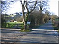
1
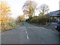
Minor road to Loggerheads at Bryn Eithen
Looking north-eastward.
Image: © Peter Wood
Taken: 22 Nov 2018
0.03 miles
2
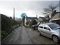
Cottage on a lane below Fron Hen near Llanferres
The cluster of cars at this cottage argues for a Sunday roast with all the trimmings maybe. Possibly a few generations of a family are tucking in as I pass on a Sunday lunchtime. Suppressing a pang of jealousy I walked on. After all a mature cheddar and country pickle sarnie high on a windswept hillside isn't such a poor relation to a Sunday roast...
Image: © Jeremy Bolwell
Taken: 19 Feb 2012
0.20 miles
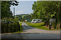
5
Road to Moel Famau
The road on the right has passed through Tafarn-y-Gelyn on its way uphill to Bwlch Penbarras, the main car park for Moel Famau. On the left is the Bryn Bowlio caravan park.
Image: © John S Turner
Taken: 23 Jan 2007
0.23 miles