IMAGES TAKEN NEAR TO
Denbigh Road, MOLD, CH7 5RH
Introduction
This page details the photographs taken nearby to Denbigh Road, CH7 5RH by members of the Geograph project.
The Geograph project started in 2005 with the aim of publishing, organising and preserving representative images for every square kilometre of Great Britain, Ireland and the Isle of Man.

There are currently over 7.5m images from over14,400 individuals and you can help contribute to the project by visiting https://www.geograph.org.uk
Image Map
Images are licensed for reuse under creativecommons.org/licenses/by-sa/2.0
Notes
- Clicking on the map will re-center to the selected point.
- The higher the marker number, the further away the image location is from the centre of the postcode.
Image Listing (5 Images Found)
Images are licensed for reuse under creativecommons.org/licenses/by-sa/2.0
Image
Details
Distance
2
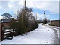
Farm lanes
Snow covered farm lanes near to the village of Ysceifiog
Image: © Dot Potter
Taken: 5 Mar 2006
0.13 miles
3
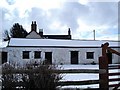
Ysceifiog farm building
Barn near to the village of Ysceifiog
Image: © Dot Potter
Taken: 5 Mar 2006
0.13 miles
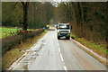
4
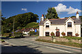
Sarn Farm
House alongside the A541 near Sarn Farm.
Image: © Peter McDermott
Taken: 26 Sep 2015
0.23 miles