IMAGES TAKEN NEAR TO
Denbigh Road, MOLD, CH7 5RB
Introduction
This page details the photographs taken nearby to Denbigh Road, CH7 5RB by members of the Geograph project.
The Geograph project started in 2005 with the aim of publishing, organising and preserving representative images for every square kilometre of Great Britain, Ireland and the Isle of Man.

There are currently over 7.5m images from over14,400 individuals and you can help contribute to the project by visiting https://www.geograph.org.uk
Image Map
Images are licensed for reuse under creativecommons.org/licenses/by-sa/2.0
Notes
- Clicking on the map will re-center to the selected point.
- The higher the marker number, the further away the image location is from the centre of the postcode.
Image Listing (10 Images Found)
Images are licensed for reuse under creativecommons.org/licenses/by-sa/2.0
Image
Details
Distance
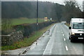
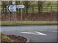
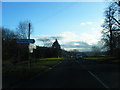
1
Route out
Road south from Nannerch towards junction with A541.
Image: © J Scott
Taken: 17 Feb 2011
0.01 miles
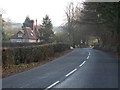
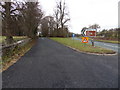
2
No entry
Nannerch village road curves to meet with the A541 Mold to Denbigh road.
Image: © J Scott
Taken: 11 Jan 2011
0.07 miles
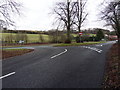
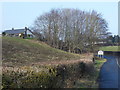
5
One quarter
Junction off the A541 leading to Nannerch village.
Image: © J Scott
Taken: 11 Jan 2011
0.09 miles
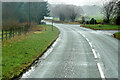
6
Nannerch road
Road to Nannerch village off the A541.
Image: © J Scott
Taken: 17 Feb 2011
0.12 miles
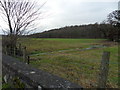
7
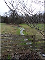
Spring waters
A stream flows from an upland spring to a culvert beneath the A541 near Nannerch.
Image: © J Scott
Taken: 11 Jan 2011
0.12 miles
9
Walled water
Spring water from Clwydian hills flows towards the A541 near Nannerch.
Image: © J Scott
Taken: 11 Jan 2011
0.13 miles