IMAGES TAKEN NEAR TO
Pentre Road, MOLD, CH7 5PD
Introduction
This page details the photographs taken nearby to Pentre Road, CH7 5PD by members of the Geograph project.
The Geograph project started in 2005 with the aim of publishing, organising and preserving representative images for every square kilometre of Great Britain, Ireland and the Isle of Man.

There are currently over 7.5m images from over14,400 individuals and you can help contribute to the project by visiting https://www.geograph.org.uk
Image Map
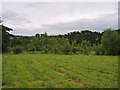
Images are licensed for reuse under creativecommons.org/licenses/by-sa/2.0
Notes
- Clicking on the map will re-center to the selected point.
- The higher the marker number, the further away the image location is from the centre of the postcode.
Image Listing (57 Images Found)
Images are licensed for reuse under creativecommons.org/licenses/by-sa/2.0
Image
Details
Distance
1

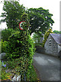
Houseleek on a roof
The houseleek is the common name of a succulent plant of the genus Sempervivum. Translated from Latin it means "always living". It needs little soil and very good drainage. Here it is thriving between roof slates on Tyddyn Mihangel, a cottage to the southwest of Cilcain. Keeping it company looks to be a stonecrop, a type of sedum.
Image: © michael ely
Taken: 10 May 2008
0.03 miles
2

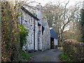
Tyddyn Mihangel
A cottage on the southwestern outskirts of Cilcain in the Clwydian foothills.
Image: © michael ely
Taken: 10 May 2008
0.05 miles
3
Overgrown speed limit sign
Entering Cilcain from the south. The church tower is just visible beyond the stone cottage
Image: © michael ely
Taken: 10 May 2008
0.06 miles
4
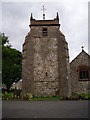
St Mary's Church, Cilcain
Medieval double naved church. The gravestones have been moved to create a parking space. https://cpat.org.uk/Archive/churches/flint/16747.htm
Image: © Eirian Evans
Taken: 8 Jul 2006
0.09 miles
5
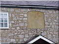
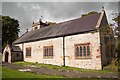
Plaque, the Old School at Cilcain
Plaque above the door of the old school in Cilcain, which was built in 1799 by public subscription. The stone above the door reads "This Building was Erected on the Common by a Voluntary Subscription from the Landowners and Occupiers of Land in this parish as a School for the use and Benefit of the Parishioners 1799".
Image: © Eirian Evans
Taken: 8 Jul 2006
0.09 miles
6
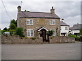
The Old School, Cilcain
The old school in Cilcain, which was built in 1799 by public subscription. The stone above the door reads "This Building was Erected on the Common by a Voluntary Subscription from the Landowners and Occupiers of Land in this parish as a School for the use and Benefit of the Parishioners 1799".
Image: © Eirian Evans
Taken: 8 Jul 2006
0.09 miles
7
Coed y Felin
Coed y Felin is a 1.6ha Woods On Your Doorstep (WOYD) site, situated c200m from Cilcain village within the Clwydian Range AONB.The site was designed, named and planted with the help of the local community in late 2000 and the trees are establishing very well. The key features present are new native woodland, adjoining ancient woodland, educational use, and informal public access.
Image: © Eirian Evans
Taken: 8 Jul 2006
0.12 miles
8
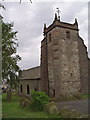
St Mary's Church, Cilcain
Medieval double naved church. https://cpat.org.uk/Archive/churches/flint/16747.htm
Image: © Eirian Evans
Taken: 8 Jul 2006
0.12 miles
10
St Mary's Church, Cilcain
St Mary's Church in Cilcain is designated by Cadw as a Grade I listed building.
Wikipedia https://en.wikipedia.org/wiki/St_Mary%27s_Church,_Cilcain
Image: © Jeff Buck
Taken: 2 Oct 2017
0.13 miles