IMAGES TAKEN NEAR TO
Glyndwr Road, MOLD, CH7 5LW
Introduction
This page details the photographs taken nearby to Glyndwr Road, CH7 5LW by members of the Geograph project.
The Geograph project started in 2005 with the aim of publishing, organising and preserving representative images for every square kilometre of Great Britain, Ireland and the Isle of Man.

There are currently over 7.5m images from over14,400 individuals and you can help contribute to the project by visiting https://www.geograph.org.uk
Image Map
Images are licensed for reuse under creativecommons.org/licenses/by-sa/2.0
Notes
- Clicking on the map will re-center to the selected point.
- The higher the marker number, the further away the image location is from the centre of the postcode.
Image Listing (9 Images Found)
Images are licensed for reuse under creativecommons.org/licenses/by-sa/2.0
Image
Details
Distance
1
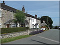
Row of cottages
On Glyndwr Road, in the hills southwest of Gwernymynydd.
Image: © Eirian Evans
Taken: 18 Jul 2017
0.08 miles
2
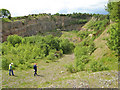
Access road, Cambrian Quarry
A view of the access road to this disused quarry, principally developed in the Carboniferous (Namurian) Cefn y Fedw Sandstone, seen dipping to the left and towards the camera, which was extracted for use in Vim scouring powder.
Image: © Jonathan Wilkins
Taken: 11 Jun 2011
0.12 miles
3
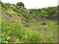
Cambrian Quarry
This view of the disused quarry shows the pronounced easterly dip of the strata. The target of extraction was originally a pure bed of sandstone known as the Cefn y Fedw Sandstone, of Carboniferous (Namurian) age, which was used for the manufacture of Vim scouring powder. In more recent time, the underlying, finely bedded, pink and grey-coloured sandstones were extracted.
Image: © Jonathan Wilkins
Taken: 11 Jun 2011
0.13 miles
4
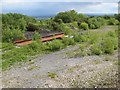
Disused quarry plant
The remains of a weighbridge and fuel tanks at the disused Cambrian Quarry.
Image: © Jonathan Wilkins
Taken: 11 Jun 2011
0.15 miles
6
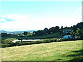
Farmland at Fron Uchaf
Looking east, with the cement factory at Buckley a prominent landmark in the distance.
Image: © David Medcalf
Taken: 21 Aug 2006
0.22 miles
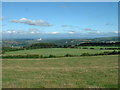
7
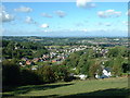
Looking down on Gwernymynydd
Looking north east, from the minor road running south from the A494, which gives splendid views of the area.
Image: © David Medcalf
Taken: 21 Aug 2006
0.23 miles
8
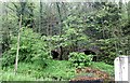
Lime kilns, Gwernymynydd
Now forming the background to the Eagles and Crawford Coaches firm who work out of the former quarry yard alongside the main road.
Image: © Alan Murray-Rust
Taken: 9 May 2019
0.24 miles
9
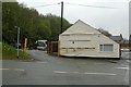
Eagles and Crawford Coaches, Gwernymynydd
The coach firm occupies what was formerly the yard of a limestone quarry occupying the wooded hillside to the left. The building on the right is shown as a smithy on early OS maps, later forming part of the quarry buildings.
Image: © Alan Murray-Rust
Taken: 9 May 2019
0.25 miles