IMAGES TAKEN NEAR TO
Gwernymynydd, MOLD, CH7 5LD
Introduction
This page details the photographs taken nearby to CH7 5LD by members of the Geograph project.
The Geograph project started in 2005 with the aim of publishing, organising and preserving representative images for every square kilometre of Great Britain, Ireland and the Isle of Man.

There are currently over 7.5m images from over14,400 individuals and you can help contribute to the project by visiting https://www.geograph.org.uk
Image Map
Images are licensed for reuse under creativecommons.org/licenses/by-sa/2.0
Notes
- Clicking on the map will re-center to the selected point.
- The higher the marker number, the further away the image location is from the centre of the postcode.
Image Listing (5 Images Found)
Images are licensed for reuse under creativecommons.org/licenses/by-sa/2.0
Image
Details
Distance
1
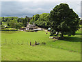
Aberduna Farm
A view over the well-kept paddocks to the farmhouse.
Image: © Jonathan Wilkins
Taken: 11 Jun 2011
0.03 miles
2
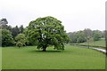
Oak tree at Aberduna
Part of the landscaped parkland of Aberduna Hall.
Image: © Alan Murray-Rust
Taken: 9 May 2019
0.10 miles
3
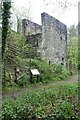
Aberduna engine house
Built to house a 48hp Cornish pumping engine for a lead mine. Partially encroached on by spoil from a later quarry, it had conservation work carried out in 2009. Listed Grade II.
Image: © Alan Murray-Rust
Taken: 9 May 2019
0.20 miles
4
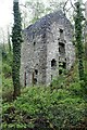
Aberduna engine house
Built to house a 48hp Cornish pumping engine for a lead mine. Partially encroached on by spoil from a later quarry, it had conservation work carried out in 2009. Listed Grade II.
Image: © Alan Murray-Rust
Taken: 9 May 2019
0.20 miles
5
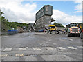
Quarry plant, Aberduna
Crushing, screening and storage silos at the top of Aberduna Quarry which is run by Hanson Aggregates to produce limestone.
Image: © Jonathan Wilkins
Taken: 11 Jun 2011
0.23 miles