IMAGES TAKEN NEAR TO
Llyn-y-Pandy, MOLD, CH7 5JF
Introduction
This page details the photographs taken nearby to Llyn-y-Pandy, CH7 5JF by members of the Geograph project.
The Geograph project started in 2005 with the aim of publishing, organising and preserving representative images for every square kilometre of Great Britain, Ireland and the Isle of Man.

There are currently over 7.5m images from over14,400 individuals and you can help contribute to the project by visiting https://www.geograph.org.uk
Image Map
Images are licensed for reuse under creativecommons.org/licenses/by-sa/2.0
Notes
- Clicking on the map will re-center to the selected point.
- The higher the marker number, the further away the image location is from the centre of the postcode.
Image Listing (4 Images Found)
Images are licensed for reuse under creativecommons.org/licenses/by-sa/2.0
Image
Details
Distance
1
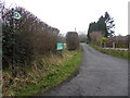
Caravan Road
Private road and footpath leading to Pantymwyn caravan park.
Image: © J Scott
Taken: 17 Feb 2011
0.04 miles
2
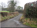
Path Bend
Footpath junction off country lane leading to Pantymwyn.
Image: © J Scott
Taken: 17 Feb 2011
0.06 miles
3
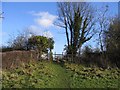
Footpath and Stile at Pantymwyn
This footpath is shown on the map as entering a wood, in fact, over the stile, it now enters a caravan park. Some trees have been retained, but it is definitely not 'as map'.
Image: © John S Turner
Taken: 14 Jan 2007
0.17 miles
4
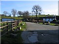
Cottage at Pantymwyn
Near the entrance to Pantymwyn Caravan Park
Image: © John S Turner
Taken: 14 Jan 2007
0.25 miles