IMAGES TAKEN NEAR TO
Pantymwyn, MOLD, CH7 5HY
Introduction
This page details the photographs taken nearby to CH7 5HY by members of the Geograph project.
The Geograph project started in 2005 with the aim of publishing, organising and preserving representative images for every square kilometre of Great Britain, Ireland and the Isle of Man.

There are currently over 7.5m images from over14,400 individuals and you can help contribute to the project by visiting https://www.geograph.org.uk
Image Map
Images are licensed for reuse under creativecommons.org/licenses/by-sa/2.0
Notes
- Clicking on the map will re-center to the selected point.
- The higher the marker number, the further away the image location is from the centre of the postcode.
Image Listing (4 Images Found)
Images are licensed for reuse under creativecommons.org/licenses/by-sa/2.0
Image
Details
Distance
1
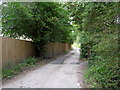
Tower Lane
Footpath track off Tower Lane,Pantymwyn.
Image: © J Scott
Taken: 13 Sep 2011
0.03 miles
2
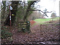
Public footpath north across Mold Golf Course
This public footpath crosses Mold Golf Course from an unclassified road, north to Cilcain Road - Image
Image: © John S Turner
Taken: 4 Dec 2018
0.10 miles
3
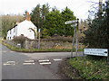
Cefn Bychan Road crossroads, Pantymwyn
Cefn Bychan Road crossroads with Pant y Buarth Road, Pantymwyn. There is an old fingerpost on the corner Image
Image: © John S Turner
Taken: 7 Feb 2018
0.16 miles
4
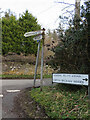
Fingerpost by Cefn Bychan Road crossroads, Pantymwyn
The 'no through road' to the right leads to a footpath into the Loggerheads Country Park. For a wider view see: Image
The 'MOLD' arm was lost by 2021.
Image: © John S Turner
Taken: 7 Feb 2018
0.17 miles