IMAGES TAKEN NEAR TO
Pen Y Fron Road, MOLD, CH7 5HT
Introduction
This page details the photographs taken nearby to Pen Y Fron Road, CH7 5HT by members of the Geograph project.
The Geograph project started in 2005 with the aim of publishing, organising and preserving representative images for every square kilometre of Great Britain, Ireland and the Isle of Man.

There are currently over 7.5m images from over14,400 individuals and you can help contribute to the project by visiting https://www.geograph.org.uk
Image Map
Images are licensed for reuse under creativecommons.org/licenses/by-sa/2.0
Notes
- Clicking on the map will re-center to the selected point.
- The higher the marker number, the further away the image location is from the centre of the postcode.
Image Listing (3 Images Found)
Images are licensed for reuse under creativecommons.org/licenses/by-sa/2.0
Image
Details
Distance
1
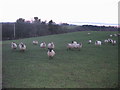
Zombie sheep!
A view looking northeast over grazing land on the southern slopes of the Alyn Valley. The fading light levels have triggered the auto-flash, creating an unusual effect in the eyes of the sheep watching a Geonerd at play.
Image: © Phil Williams
Taken: 1 Jan 2006
0.18 miles
2
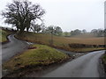
Llyn - y - Pandy
Cross roads left turn to Llyn - y - Pandy.
Image: © J Scott
Taken: 17 Feb 2011
0.20 miles
3
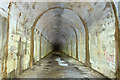
Ministry of Supply Factory, Valley, Rhydymwyn: central tunnel
Peering into the gloom from the viewing gallery of the central entrance tunnel, there is certainly no discernible light at the end of its 250m long length. This is as far as one is allowed to go at the present time.
2018 Tunnel Tour: Image
Image
Image: © Mike Searle
Taken: 16 May 2016
0.24 miles