IMAGES TAKEN NEAR TO
Rhydymwyn Road, MOLD, CH7 5HS
Introduction
This page details the photographs taken nearby to Rhydymwyn Road, CH7 5HS by members of the Geograph project.
The Geograph project started in 2005 with the aim of publishing, organising and preserving representative images for every square kilometre of Great Britain, Ireland and the Isle of Man.

There are currently over 7.5m images from over14,400 individuals and you can help contribute to the project by visiting https://www.geograph.org.uk
Image Map
Images are licensed for reuse under creativecommons.org/licenses/by-sa/2.0
Notes
- Clicking on the map will re-center to the selected point.
- The higher the marker number, the further away the image location is from the centre of the postcode.
Image Listing (19 Images Found)
Images are licensed for reuse under creativecommons.org/licenses/by-sa/2.0
Image
Details
Distance
1
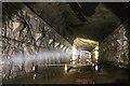
Rhydymwyn Tunnel Tour 2018 (3)
One of the four storage caverns. From 1939 onwards, the bulk storage of mustard gas and chemically charged ordnance would have been stored here.
Image: © Mike Searle
Taken: 20 May 2018
0.13 miles
2
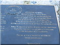
Valley Works, Rhydymwyn
Detail of the plaque outside the Valley Works site at Rhydymwyn.
Image: © Phil Williams
Taken: 1 Jan 2006
0.13 miles
3
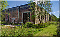
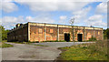
Ministry of Supply Factory, Valley, Rhydymwyn: Building P6 No. 45
South and west elevations.
Image
Image: © Mike Searle
Taken: 16 May 2016
0.14 miles
4
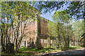
Ministry of Supply Factory, Valley, Rhydymwyn: Building P6 No. 45
A brief history: this 35 hectare site in the Alyn Valley was used during the Second World War by the UK government for the storage and production of mustard gas, to enable it to retaliate in kind if Nazi Germany (as expected) were the first to use it as a chemical weapon. The factory opened in 1941 with over 100 specialised buildings across the site producing Pyro and Runcol variants of mustard gas, although it was the more stable and purer Runcol that was eventually made in bulk. As a consequence, Building P6 No. 45 previously used to produce Pyro became surplus, and in 1942 was adapted for experiments by gaseous diffusion units to separate uranium 235 on an industrial scale. The purpose of this top secret programme, code named 'Tube Alloys', was to produce the fuel required for an atomic bomb. For a very brief period this building was at the forefront of nuclear physics before the whole process was moved to America to be developed into the Manhattan Project.
Now of international importance, Building P6 No. 45 has been listed Grade II and is by far the most important structure surviving on the Valley site.
Key Facts:
• The Valley site was constructed between 1939-41 to store and manufacture mustard gas.
...
• By 1943 there were 2,200 people working here in over 100 buildings.
...
• It had its own railway, a siding of the main Denbigh to Mold line that was used to bring materials to the site.
...
• The factory cost £3.2 million in 1939 equating to approximately £54 million today.
...
• The site was top secret, even the Luftwaffe didn't know of its existence, and was deliberately not shown on maps.
...
• Production ceased in 1945 when 5000 tons of mustard gas was stored here as the UK strategic reserve until 1958.
...
• Building 45 (P6) from 1942-45 was where the 'Tube Alloys' atomic bomb experimental project was conducted that included amongst its scientists, the 'atom spy' Klaus Fuchs.
...
• By 1943-44 most of the Valley scientists had left to work on the Manhattan Project in America.
...
• The Manhattan Project resulted in the production of the atomic bombs "Little Boy" and "Fat Man" that destroyed Hiroshima and Nagasaki in 1945, ending the war in the Far East.
...
• Ostensibly during the post-war years the site was a 'food storage depot'. In reality it was a secret designated storage site for the UK's Gold Reserves during the Cold War in the event of hostilities. In effect, Britain's equivalent to Fort Knox. Today the site is managed by DEFRA as a nature reserve.
...
• Many of the buildings have been listed Grade II, and the tunnels and 21 "Danger Area" buildings designated ancient monuments by CADW
...
• Managed access to the site is by membership of the Rhydymwyn Valley History Society: https://rhydymwynvalleyhistory.co.uk/
VIRTUAL 360° TUNNELS TOUR: http://www.conquest-drones.com/Customer_Demonstrations/rhydymwyn/Rhydymwyn-Valley-Works.html
Image
Image: © Mike Searle
Taken: 16 May 2016
0.15 miles
5
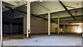
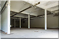
Ministry of Supply Factory,Valley, Rhydymwyn: Building P6 No. 45
Building interior.
Image
Image: © Mike Searle
Taken: 16 May 2016
0.15 miles
6
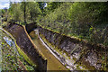
Ministry of Supply Factory, Valley, Rhydymwyn: Culvert diversion
Before building of the Valley site could commence, the diversion of the River Alyn through the site became a priority in order to prevent flooding. A culvert was built in 1939 to a design by Sir Eric Driver that could cope with upwards of more than twice the amount of water over the previous 100 years. However, when the site flooded in 1941 after unprecedented snowfall caused 4 times the amount of water to flow, a relief channel was built here in the summer of 1941.
Image
Image: © Mike Searle
Taken: 16 May 2016
0.16 miles
7
Ministry of Supply Factory, Valley, Rhydymwyn: Building R3 No. 65
Building R3 is the only surviving building of two Runcol manufacturing plants on this site (R3 & R4), and were the only buildings to have produced this variant of mustard gas. Building R3 is also Grade II listed.
Image
Image: © Mike Searle
Taken: 16 May 2016
0.16 miles
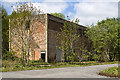
8
Bat house
Former Top Secret building at the site which is now a home for bat species in the area.
Image: © Malcolm Campbell
Taken: 22 Oct 2007
0.16 miles
9
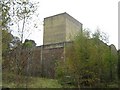
Ministry of Supply Factory, Valley, Rhydymwyn: Building P4 No. 59
P4 and P5 were two buildings that produced the Pyro variant of mustard gas, and as a result of over capacity Building P4 seen here became a fully operational back-up to Building P5. Building P4 is Grade II listed.
Image
Image: © Mike Searle
Taken: 16 May 2016
0.20 miles
10
Ministry of Supply Factory, Valley, Rhydymwyn: Building P4 No. 59
Building interior.
Image
Image: © Mike Searle
Taken: 16 May 2016
0.21 miles