IMAGES TAKEN NEAR TO
Vicarage Road, MOLD, CH7 5HL
Introduction
This page details the photographs taken nearby to Vicarage Road, CH7 5HL by members of the Geograph project.
The Geograph project started in 2005 with the aim of publishing, organising and preserving representative images for every square kilometre of Great Britain, Ireland and the Isle of Man.

There are currently over 7.5m images from over14,400 individuals and you can help contribute to the project by visiting https://www.geograph.org.uk
Image Map
Images are licensed for reuse under creativecommons.org/licenses/by-sa/2.0
Notes
- Clicking on the map will re-center to the selected point.
- The higher the marker number, the further away the image location is from the centre of the postcode.
Image Listing (12 Images Found)
Images are licensed for reuse under creativecommons.org/licenses/by-sa/2.0
Image
Details
Distance
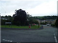
2
Dolfechlas Road in Rhydymwyn
Looking north-westward.
Image: © Peter Wood
Taken: 22 Nov 2018
0.10 miles
4
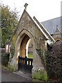
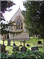
Arch way
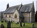
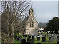
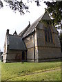
Entrance gate to St. John the Evangelist, constructed in 1949 by P. R. Davies-Cooke in memory of his father.
Image: © J Scott
Taken: 17 Feb 2011
0.17 miles
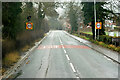
8
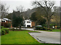
Rhydymwyn
Rhydymwyn is a village located in the upper Alyn valley in Flintshire. Once a district of Mold, it was recognised as a separate parish from 1865.
The village takes its placename from the ford across the River Alyn (now replaced by a small iron bridge); the name in Welsh means 'Ford of the Ore' (https://en.wikipedia.org/wiki/Rhydymwyn Wikipedia).
Image: © David Dixon
Taken: 18 Feb 2022
0.19 miles
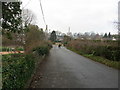
10
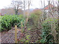
Fence enclosed footpath between Dolfechlas Road and A541 in Rhydymwyn
Looking north-eastward.
Image: © Peter Wood
Taken: 22 Nov 2018
0.21 miles