IMAGES TAKEN NEAR TO
Hafod Moor, MOLD, CH7 5ET
Introduction
This page details the photographs taken nearby to Hafod Moor, CH7 5ET by members of the Geograph project.
The Geograph project started in 2005 with the aim of publishing, organising and preserving representative images for every square kilometre of Great Britain, Ireland and the Isle of Man.

There are currently over 7.5m images from over14,400 individuals and you can help contribute to the project by visiting https://www.geograph.org.uk
Image Map
Images are licensed for reuse under creativecommons.org/licenses/by-sa/2.0
Notes
- Clicking on the map will re-center to the selected point.
- The higher the marker number, the further away the image location is from the centre of the postcode.
Image Listing (6 Images Found)
Images are licensed for reuse under creativecommons.org/licenses/by-sa/2.0
Image
Details
Distance
2
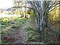
Stile into an enclosed footpath
On a footpath heading east from Cadole Road
Image: © Maggie Cox
Taken: 10 Nov 2013
0.06 miles
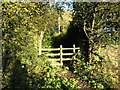
3
Stile and signpost at a junction of paths in fields
Turn right to head for Gwernymynydd and left in the direction of Gwernaffield
Image: © Maggie Cox
Taken: 10 Nov 2013
0.12 miles
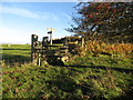
5
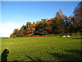
Grazing field beside woodland
From a footpath heading south to Gwernymynydd
Image: © Maggie Cox
Taken: 10 Nov 2013
0.22 miles
6
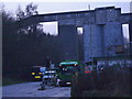
Cefn Mawr Quarry
Limestone quarry near Cadole.
Image: © Eirian Evans
Taken: 15 Mar 2006
0.22 miles