IMAGES TAKEN NEAR TO
Cefn Bychan Woods, MOLD, CH7 5EP
Introduction
This page details the photographs taken nearby to Cefn Bychan Woods, CH7 5EP by members of the Geograph project.
The Geograph project started in 2005 with the aim of publishing, organising and preserving representative images for every square kilometre of Great Britain, Ireland and the Isle of Man.

There are currently over 7.5m images from over14,400 individuals and you can help contribute to the project by visiting https://www.geograph.org.uk
Image Map
Images are licensed for reuse under creativecommons.org/licenses/by-sa/2.0
Notes
- Clicking on the map will re-center to the selected point.
- The higher the marker number, the further away the image location is from the centre of the postcode.
Image Listing (15 Images Found)
Images are licensed for reuse under creativecommons.org/licenses/by-sa/2.0
Image
Details
Distance
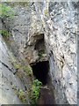
1
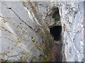
Devil's Hole in the Alyn Valley
The cliffs here are popular with rock climbers, especially the overhangs apparently.
Image: © Jeremy Bolwell
Taken: 16 Nov 2011
0.13 miles
2
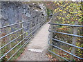
Footbridge above Devil's Hole
A reassuringly sturdy bridge from which to look down on the old mining shaft called Devil's Hole.
Image: © Jeremy Bolwell
Taken: 16 Nov 2011
0.13 miles
3
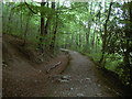
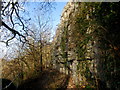
Leete Path
The Leete path is a footpath between Loggerheads and Cilcain and it also makes up part of the Clwydian Way. The leete here was originally a 2 metres wide and 1.5metre deep water channel which was built to divert water from the river at Loggerheads in order to service the nearby water mills year-round. The River Alyn usually disappears during part of the year due to swallow holes in the limestone river bed. The footpath rises slowly above the river, being at the same height as the river at Loggerheads, to being several metres above it where this photograph was taken (and even more so nearer Cilcain).
Image: © David Quinn
Taken: 7 Oct 2007
0.13 miles
4
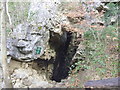
Old mine beside The Leete path
This is an underground working probably for Calcite dating from pre-war 20th C. it doesn't appear on the 1910 OS map. The width of the vertical vein can be seen as well a some wooden pit props. There is another similar working a few yards W.
Image: © John Harrison
Taken: 22 Feb 2014
0.13 miles
5
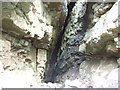
Inside old Calcite mine along The Leete path
This is just inside the underground working, probably for Calcite and dating from pre-war 20th C. It doesn't appear on the 1910 OS map. The width of the vertical vein can be seen as well a some wooden pit props.
Image: © John Harrison
Taken: 22 Feb 2014
0.14 miles
7
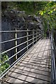
Gorge bridge
Footpath bridge over the Devil's Gorge, near Loggerheads.
Image: © J Scott
Taken: 30 Sep 2010
0.15 miles
8
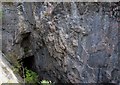
Devil's hole
Devil's Gorge viewed from Leete footpath bridge.
Image: © J Scott
Taken: 30 Sep 2010
0.15 miles
9
Ceubwll y Diafol (Devil's Gorge)
In years gone by, the limestone cliffs at Loggerheads were mined for lead. The two walls at the entrance of the cave are used for climbing, with fixed points, the south side having overhanging routes. You can also abseil down into the gorge itself. The photo is taken from the footbridge over the gorge.
Image: © Eirian Evans
Taken: 16 Oct 2006
0.16 miles
10
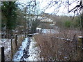
Footbridge across the Afon Alun / River Alyn below Bryn y Castell
This path and bridge is popular: the snow fell overnight and at 9.00 a.m. (ish) this path is already fairly well trodden.
Image: © Jeremy Bolwell
Taken: 19 Feb 2012
0.16 miles