IMAGES TAKEN NEAR TO
Pen Y Cefn, MOLD, CH7 5BW
Introduction
This page details the photographs taken nearby to Pen Y Cefn, CH7 5BW by members of the Geograph project.
The Geograph project started in 2005 with the aim of publishing, organising and preserving representative images for every square kilometre of Great Britain, Ireland and the Isle of Man.

There are currently over 7.5m images from over14,400 individuals and you can help contribute to the project by visiting https://www.geograph.org.uk
Image Map
Images are licensed for reuse under creativecommons.org/licenses/by-sa/2.0
Notes
- Clicking on the map will re-center to the selected point.
- The higher the marker number, the further away the image location is from the centre of the postcode.
Image Listing (3 Images Found)
Images are licensed for reuse under creativecommons.org/licenses/by-sa/2.0
Image
Details
Distance
1
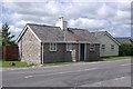
Former Tollhouse by the B5122, Caerwys
Llidiart Cerrig by the B5122, in parish of Caerwys (Flintshire District), Tollgate Cottage, Crossways Road, Pen y Cefn, CH7 5BP.
To be surveyed
Milestone Society National ID: FLT.CAE01
Image: © Milestone Society
Taken: Unknown
0.12 miles
2
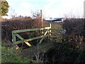
Permissive Bridge
Access footbridge to Flintshire County Council permissive footpath (20) across fields of Wern Fawr Farm.
Image: © J Scott
Taken: 19 Jan 2011
0.23 miles
3
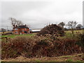
9 months to go til Bonfire Night
If it's this big in February, just think how big it will be by November!
Image: © Eirian Evans
Taken: 12 Feb 2019
0.23 miles