IMAGES TAKEN NEAR TO
Pen Y Cefn, MOLD, CH7 5BQ
Introduction
This page details the photographs taken nearby to Pen Y Cefn, CH7 5BQ by members of the Geograph project.
The Geograph project started in 2005 with the aim of publishing, organising and preserving representative images for every square kilometre of Great Britain, Ireland and the Isle of Man.

There are currently over 7.5m images from over14,400 individuals and you can help contribute to the project by visiting https://www.geograph.org.uk
Image Map
Images are licensed for reuse under creativecommons.org/licenses/by-sa/2.0
Notes
- Clicking on the map will re-center to the selected point.
- The higher the marker number, the further away the image location is from the centre of the postcode.
Image Listing (6 Images Found)
Images are licensed for reuse under creativecommons.org/licenses/by-sa/2.0
Image
Details
Distance
1
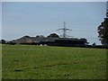
Pile On
Electricity pylon backdrops farm buildings of Ty-uchaf.
Image: © J Scott
Taken: 25 Oct 2010
0.02 miles
2
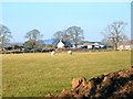
Ty Uchaf
From the viewpoint of the manure heap, looking across the sheep grazing pasture towards the farm at Ty Uchaf, just north of Caerwys.
Image: © Roger May
Taken: 30 Jan 2006
0.06 miles
3
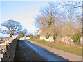
Marian Prysau
Looking west from the intersection on the B5122 towards houses at Marian Prysau, hidden behind the trees, just to the north of Caerwys.
Image: © Roger May
Taken: 30 Jan 2006
0.12 miles
4
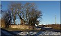
Why Junction
Minor road intersects with the B5122 north of Caerwys.
Image: © J Scott
Taken: 8 Dec 2010
0.22 miles
5
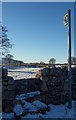
The Green Man
Stone stile to footpath in direction of Caerwys.
Image: © J Scott
Taken: 8 Dec 2010
0.22 miles
6
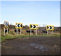
Arwyddion ffordd yn troi / Bend in road signs
Image: © Ceri Thomas
Taken: 23 Dec 2017
0.25 miles