IMAGES TAKEN NEAR TO
Maes Y Dre, Holywell Road, MOLD, CH7 5AS
Introduction
This page details the photographs taken nearby to Maes Y Dre, Holywell Road, CH7 5AS by members of the Geograph project.
The Geograph project started in 2005 with the aim of publishing, organising and preserving representative images for every square kilometre of Great Britain, Ireland and the Isle of Man.

There are currently over 7.5m images from over14,400 individuals and you can help contribute to the project by visiting https://www.geograph.org.uk
Image Map
Images are licensed for reuse under creativecommons.org/licenses/by-sa/2.0
Notes
- Clicking on the map will re-center to the selected point.
- The higher the marker number, the further away the image location is from the centre of the postcode.
Image Listing (42 Images Found)
Images are licensed for reuse under creativecommons.org/licenses/by-sa/2.0
Image
Details
Distance
1
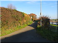
Hollywell Road leaving Caerwys
Looking north-eastward.
Image: © Peter Wood
Taken: 18 Nov 2018
0.07 miles
3
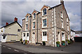
Somerville Veterinary Surgery, Caerwys
Image: © Eirian Evans
Taken: 31 Jan 2009
0.11 miles
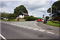
4
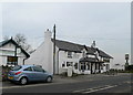
The Piccadilly Inn, Caerwys
On the B5122 north out of Caerwys.
Image: © Eirian Evans
Taken: 31 Jan 2009
0.11 miles
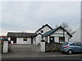
5

Bethel Methodist Chapel, Caerwys
On Water Street in Caerwys, the Welsh chapel (Bethel) and the English (Afonwen) use the same building at different times on a Sunday.
Image: © Eirian Evans
Taken: 22 Feb 2019
0.12 miles
6
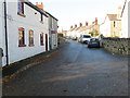
Water Street in Caerwys
Looking north-westward.
Image: © Peter Wood
Taken: 18 Nov 2018
0.12 miles


9
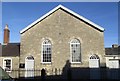
Capel Bethel
Bethel is a bilingual Presbyterian chapel.
Image: © Ceri Thomas
Taken: 23 Dec 2017
0.13 miles