IMAGES TAKEN NEAR TO
Tir Y Fron Lane, MOLD, CH7 4TY
Introduction
This page details the photographs taken nearby to Tir Y Fron Lane, CH7 4TY by members of the Geograph project.
The Geograph project started in 2005 with the aim of publishing, organising and preserving representative images for every square kilometre of Great Britain, Ireland and the Isle of Man.

There are currently over 7.5m images from over14,400 individuals and you can help contribute to the project by visiting https://www.geograph.org.uk
Image Map
Images are licensed for reuse under creativecommons.org/licenses/by-sa/2.0
Notes
- Clicking on the map will re-center to the selected point.
- The higher the marker number, the further away the image location is from the centre of the postcode.
Image Listing (7 Images Found)
Images are licensed for reuse under creativecommons.org/licenses/by-sa/2.0
Image
Details
Distance
1
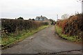
Lane at Berth
Lane at Berth leading to Waen y Llyn Country Park.
Image: © Jeff Buck
Taken: 12 Dec 2012
0.03 miles
2
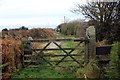
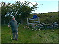
Stile and Gate at Waen y Llyn Country Park
One of the entrances to Waen y Llyn Country Park at its northern end.
Image: © Jeff Buck
Taken: 12 Dec 2012
0.05 miles
3
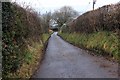
Country Lane at Berth
Lane at Berth heading east.
Image: © Jeff Buck
Taken: 12 Dec 2012
0.06 miles
4
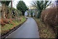
Lane to Pontybodkin
Lane heading west from Berth to Pontybodkin.
Image: © Jeff Buck
Taken: 12 Dec 2012
0.07 miles
6
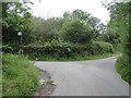
Tir-y-Fron Lane junction
Tir-y-Fron Lane continues to the right, whilst the bridleway to the left leads to Top-y-Rhos Farm and Waun-y-Llyn Country Park.
Image: © John S Turner
Taken: 8 Aug 2019
0.18 miles
7
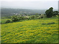
Buttercup meadow
West of Waun-y-Llyn Country Park.
Image: © John H Darch
Taken: 31 May 2018
0.20 miles