IMAGES TAKEN NEAR TO
Ffordd Corwen, Coed-Talon, MOLD, CH7 4TW
Introduction
This page details the photographs taken nearby to Ffordd Corwen, Coed-Talon, CH7 4TW by members of the Geograph project.
The Geograph project started in 2005 with the aim of publishing, organising and preserving representative images for every square kilometre of Great Britain, Ireland and the Isle of Man.

There are currently over 7.5m images from over14,400 individuals and you can help contribute to the project by visiting https://www.geograph.org.uk
Image Map
Images are licensed for reuse under creativecommons.org/licenses/by-sa/2.0
Notes
- Clicking on the map will re-center to the selected point.
- The higher the marker number, the further away the image location is from the centre of the postcode.
Image Listing (13 Images Found)
Images are licensed for reuse under creativecommons.org/licenses/by-sa/2.0
Image
Details
Distance
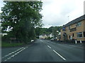
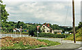
1
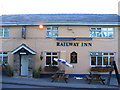
The Railway Inn, Coed-talon
There is no railway now. The railway line would have been just to the right of the pub.
Image: © Peter Craine
Taken: 24 Jul 2006
0.01 miles
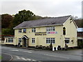
3

Railway Inn, Coedtalon
The village was served by a branch of the London and North Western Railway, who in 1892 introduced a passenger service to Coed Talon, but the station closed in 1950. The Railway Inn remains as a reminder of those days.
Image: © Eirian Evans
Taken: 10 Mar 2016
0.06 miles
5
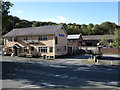
The Railway Inn and other buildings
The Railway Inn is in the village of Coed-talon on the A5104 between Treuddyn and Pontybodkin. There's no longer a railway there of course.
Image: © Trevor Littlewood
Taken: 12 Oct 2012
0.06 miles
7
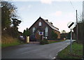
Hen Gapel Sion
Zion Chapel, Pontybodkin - built in the mid 19th century as a chapel for the Calvinistic Methodists.
Image: © Eirian Evans
Taken: 6 Jan 2007
0.07 miles
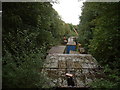
8
Railway track at Coed Talon
This footpath follows the track of the former railway track between Coed Talon and Llanfynydd. The track was part of the Mold to Brymbo line which opened in the late 19th century and was busy with trucks transporting coal, oil and stone from nearby works and mines.
Image: © Eirian Evans
Taken: 16 Sep 2007
0.09 miles
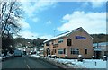
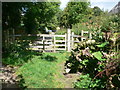
9
Pontybodkin disused station
Now full of decaying sheds and vehicles. This was once the Mold and Brymbo Branch railway, according to the '40s map.
Image: © David Medcalf
Taken: 4 Sep 2006
0.10 miles
10
Site of Coed Talon station, 1986
View NE on A5104, at the former crossing of the LNW & GW Joint line from Mold (left) to Brymbo (right). Nothing whatever is to be seen now relating to the railway, the line having been closed finally on 22/7/63, to passengers from 27/3/50.
Image: © Ben Brooksbank
Taken: 25 Jun 1986
0.10 miles