IMAGES TAKEN NEAR TO
Pontybodkin, MOLD, CH7 4TR
Introduction
This page details the photographs taken nearby to CH7 4TR by members of the Geograph project.
The Geograph project started in 2005 with the aim of publishing, organising and preserving representative images for every square kilometre of Great Britain, Ireland and the Isle of Man.

There are currently over 7.5m images from over14,400 individuals and you can help contribute to the project by visiting https://www.geograph.org.uk
Image Map
Images are licensed for reuse under creativecommons.org/licenses/by-sa/2.0
Notes
- Clicking on the map will re-center to the selected point.
- The higher the marker number, the further away the image location is from the centre of the postcode.
Image Listing (12 Images Found)
Images are licensed for reuse under creativecommons.org/licenses/by-sa/2.0
Image
Details
Distance
1
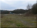
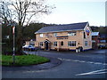
Waste land, Leeswood
To the south of the village.
Image: © Eirian Evans
Taken: 15 Feb 2008
0.03 miles
2
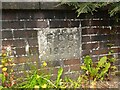
Old Bridge Marker on the A5104 Corwen Road in Pont-y-bodkin
Bridge Marker in Pont-y-bodkin, set in the parapet of a bridge on the southeast side of the A5104 Corwen Road opposite the similar FLT_FYNYDD01br. Llanfynydd community. Inscribed F.C.C. / 1936 for Flintshire County Council.
Milestone Society National ID: FLT_FYNYDD02br
Image: © C Leather
Taken: 27 Jul 2024
0.03 miles
3
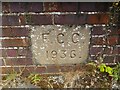
Old Bridge Marker on the A5104 Corwen Road in Pont-y-bodkin
Bridge Marker in Pont-y-bodkin, set in the parapet of a bridge on the southeast side of the A5104 Corwen Road opposite the similar FLT_FYNYDD02br. Llanfynydd community. Inscribed F.C.C. / 1936 for Flintshire County Council.
Milestone Society National ID: FLT_FYNYDD01br
Image: © C Leather
Taken: 27 Jul 2024
0.04 miles
5
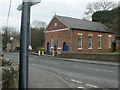
English Congregational Chapel, Leeswood
Built in 1870, it is on the A5104 at Leeswood.
Image: © Eirian Evans
Taken: 16 Feb 2008
0.06 miles
7
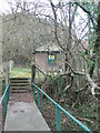
Pontybodkin Lower Pumping Station
Over a short footbridge from the A5104 near Leeswood.
Image: © Eirian Evans
Taken: 15 Feb 2008
0.12 miles
8
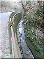
Nant Brook
Running alongside the A5104Pontybodkin to Pontblyddin road. It is a tributary of the River Alun.
Image: © Eirian Evans
Taken: 15 Feb 2008
0.18 miles
9
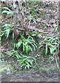
Hart's Tongue ferns
Growing alongside Nant Brook.
Image: © Eirian Evans
Taken: 16 Feb 2008
0.18 miles
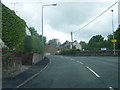
10
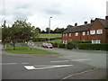
Pontybodkin houses and Playing Field
The house at the left hand end of the terrace is marked on some maps as "Police Station", but it doesn't appear to be now. Looking north east.
Image: © David Medcalf
Taken: 4 Sep 2006
0.19 miles