IMAGES TAKEN NEAR TO
Queen Street, MOLD, CH7 4RH
Introduction
This page details the photographs taken nearby to Queen Street, CH7 4RH by members of the Geograph project.
The Geograph project started in 2005 with the aim of publishing, organising and preserving representative images for every square kilometre of Great Britain, Ireland and the Isle of Man.

There are currently over 7.5m images from over14,400 individuals and you can help contribute to the project by visiting https://www.geograph.org.uk
Image Map
Images are licensed for reuse under creativecommons.org/licenses/by-sa/2.0
Notes
- Clicking on the map will re-center to the selected point.
- The higher the marker number, the further away the image location is from the centre of the postcode.
Image Listing (11 Images Found)
Images are licensed for reuse under creativecommons.org/licenses/by-sa/2.0
Image
Details
Distance
1
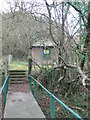
Pontybodkin Lower Pumping Station
Over a short footbridge from the A5104 near Leeswood.
Image: © Eirian Evans
Taken: 15 Feb 2008
0.17 miles
2
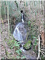
Waterfall near Leeswood
This waterfall joins Nant Brook which runs alongside the A5104
Image: © Eirian Evans
Taken: 15 Feb 2008
0.19 miles
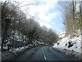
4
Nant Brook
Running alongside the A5104Pontybodkin to Pontblyddin road. It is a tributary of the River Alun.
Image: © Eirian Evans
Taken: 15 Feb 2008
0.20 miles
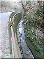
5
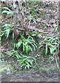
Hart's Tongue ferns
Growing alongside Nant Brook.
Image: © Eirian Evans
Taken: 16 Feb 2008
0.20 miles
6
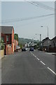
King Street Leeswood.
The red brick building on the left was a shop for many years. The name was Owens shop later it was known as Lomanoes. (Sam the shop).
Image: © Graeme Walker
Taken: 5 May 2007
0.20 miles
7
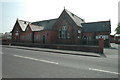
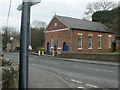
Leeswood Community Centre
The old school which is now the community centre and club.
Image: © Graeme Walker
Taken: 5 May 2007
0.23 miles
8
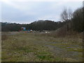
Waste land, Leeswood
To the south of the village.
Image: © Eirian Evans
Taken: 15 Feb 2008
0.23 miles
9
English Congregational Chapel, Leeswood
Built in 1870, it is on the A5104 at Leeswood.
Image: © Eirian Evans
Taken: 16 Feb 2008
0.23 miles
10
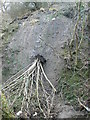
Landslide, Nant Wood
After a lot of heavy rain recently, there are several landslides down this sharp incline.
Image: © Eirian Evans
Taken: 15 Feb 2008
0.23 miles