IMAGES TAKEN NEAR TO
Llandegla Road, MOLD, CH7 4QX
Introduction
This page details the photographs taken nearby to Llandegla Road, CH7 4QX by members of the Geograph project.
The Geograph project started in 2005 with the aim of publishing, organising and preserving representative images for every square kilometre of Great Britain, Ireland and the Isle of Man.

There are currently over 7.5m images from over14,400 individuals and you can help contribute to the project by visiting https://www.geograph.org.uk
Image Map
Images are licensed for reuse under creativecommons.org/licenses/by-sa/2.0
Notes
- Clicking on the map will re-center to the selected point.
- The higher the marker number, the further away the image location is from the centre of the postcode.
Image Listing (4 Images Found)
Images are licensed for reuse under creativecommons.org/licenses/by-sa/2.0
Image
Details
Distance
1
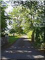
Entrance to Gelli Gynan
The gates leading to the Gelli Gynan Estate, near Llanarmon yn Iâl.
Image: © Eirian Evans
Taken: 24 Jul 2006
0.20 miles
2
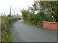
Approaching Llanarmon yn I?l from the south
The B5431 curving round towards the village.
Image: © Eirian Evans
Taken: 9 Oct 2007
0.21 miles
3
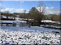
View Across the River Alyn
Viewed from the footpath below the house called Alyn Bank. In the centre of the photo is an ancient stone clapper bridge over the River Alyn, which is quite full with a lot of melting snow.
Image: © John S Turner
Taken: 11 Feb 2007
0.24 miles
4
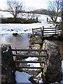
Ancient Stone Clapper Bridge.
This bridge crosses the River Alyn near Llanarmon yn Ial. It must have been a busy path at one time as it is very close to a lime kiln, and what appear to be small limestone quarries. Despite its antiquity it is not marked as a public footpath on the modern maps. I believe the prominent hill in the distance is Moel y Plas, but I'm not certain.
Image: © John S Turner
Taken: 11 Feb 2007
0.24 miles