IMAGES TAKEN NEAR TO
Back Road, MOLD, CH7 4QD
Introduction
This page details the photographs taken nearby to Back Road, CH7 4QD by members of the Geograph project.
The Geograph project started in 2005 with the aim of publishing, organising and preserving representative images for every square kilometre of Great Britain, Ireland and the Isle of Man.

There are currently over 7.5m images from over14,400 individuals and you can help contribute to the project by visiting https://www.geograph.org.uk
Image Map
Images are licensed for reuse under creativecommons.org/licenses/by-sa/2.0
Notes
- Clicking on the map will re-center to the selected point.
- The higher the marker number, the further away the image location is from the centre of the postcode.
Image Listing (3 Images Found)
Images are licensed for reuse under creativecommons.org/licenses/by-sa/2.0
Image
Details
Distance
1
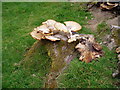
Bracket fungus
Large bracket fungus growing on a tree stump.
Image: © Eirian Evans
Taken: 9 Jul 2006
0.10 miles
2
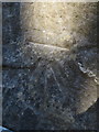
Bench mark on the gatepost for Cyfnant-Uchaf
This Ordnance Survey bench mark is on the south face of the right-hand gatepost for Cyfnant-Uchaf alongside the unclassified road. See also Image
Image: © John S Turner
Taken: 25 Feb 2018
0.21 miles
3
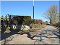
Unclassified road north of Llanarmon yn I
Looking north along the unclassified road near the gateway to Cyfnant-Uchaf. There is an Ordnance Survey bench mark on the gatepost at the far left of the photo - Image
Image: © John S Turner
Taken: 25 Feb 2018
0.21 miles