IMAGES TAKEN NEAR TO
Ffordd Y Gilrhos, MOLD, CH7 4NW
Introduction
This page details the photographs taken nearby to Ffordd Y Gilrhos, CH7 4NW by members of the Geograph project.
The Geograph project started in 2005 with the aim of publishing, organising and preserving representative images for every square kilometre of Great Britain, Ireland and the Isle of Man.

There are currently over 7.5m images from over14,400 individuals and you can help contribute to the project by visiting https://www.geograph.org.uk
Image Map
Images are licensed for reuse under creativecommons.org/licenses/by-sa/2.0
Notes
- Clicking on the map will re-center to the selected point.
- The higher the marker number, the further away the image location is from the centre of the postcode.
Image Listing (4 Images Found)
Images are licensed for reuse under creativecommons.org/licenses/by-sa/2.0
Image
Details
Distance
1
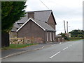
Chapel and vestry on Ffordd y Rhos, Treuddyn
Image: © Eirian Evans
Taken: 27 Sep 2009
0.12 miles
3
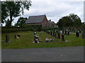
Mynwent y Rhos, Treuddyn
The Cemetery in Treuddyn, Ebeneser Chapel can be seen beyond.
Image: © Eirian Evans
Taken: 27 Sep 2009
0.21 miles
4
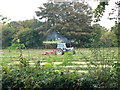
Making hay while the sun shines
A tractor with a hay bob driving over cut rows of grass to rough up drying grass. This helps remove moisture more quickly to make baling easier.
Image: © Eirian Evans
Taken: 27 Sep 2009
0.22 miles