IMAGES TAKEN NEAR TO
Padeswood Drive, Chester Road, MOLD, CH7 4JQ
Introduction
This page details the photographs taken nearby to Padeswood Drive, Chester Road, CH7 4JQ by members of the Geograph project.
The Geograph project started in 2005 with the aim of publishing, organising and preserving representative images for every square kilometre of Great Britain, Ireland and the Isle of Man.

There are currently over 7.5m images from over14,400 individuals and you can help contribute to the project by visiting https://www.geograph.org.uk
Image Map
Images are licensed for reuse under creativecommons.org/licenses/by-sa/2.0
Notes
- Clicking on the map will re-center to the selected point.
- The higher the marker number, the further away the image location is from the centre of the postcode.
Image Listing (6 Images Found)
Images are licensed for reuse under creativecommons.org/licenses/by-sa/2.0
Image
Details
Distance
1
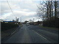
A5118 at turn for Padeswood Cement Works
Image: © Colin Pyle
Taken: 17 Feb 2015
0.09 miles
2
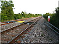
Stop Look Listen!
A sign warns you to beware of trains here where the footpath crosses the railway line which is south of Buckley heading for Wrexham
Image: © Maggie Cox
Taken: 25 Aug 2013
0.17 miles
3
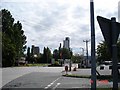
Cement works Padeswood
Entrance to the cement works at Padeswood
Image: © Dot Potter
Taken: 14 Aug 2005
0.18 miles
4
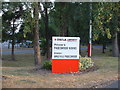
Welcome to Padeswood Works
Sign at the entrance to the very prominent cement factory, which is visible for miles around.
Image: © David Medcalf
Taken: 25 Jul 2006
0.19 miles
5

Padeswood railway bridge
Looking west along the A5118 towards the Padeswood railway bridge. There is an Ordnance Survey bench mark on the right hand, east face of the bridge - see Image
Image: © John S Turner
Taken: 23 Jun 2010
0.20 miles
6

Bench mark on Padeswood railway bridge
This bench mark is on the east face of Padeswood railway bridge alongside the A5118. See also Image
Image: © John S Turner
Taken: 23 Jun 2010
0.20 miles