IMAGES TAKEN NEAR TO
Church Terrace, Wrexham Road, MOLD, CH7 4HQ
Introduction
This page details the photographs taken nearby to Church Terrace, Wrexham Road, CH7 4HQ by members of the Geograph project.
The Geograph project started in 2005 with the aim of publishing, organising and preserving representative images for every square kilometre of Great Britain, Ireland and the Isle of Man.

There are currently over 7.5m images from over14,400 individuals and you can help contribute to the project by visiting https://www.geograph.org.uk
Image Map
Images are licensed for reuse under creativecommons.org/licenses/by-sa/2.0
Notes
- Clicking on the map will re-center to the selected point.
- The higher the marker number, the further away the image location is from the centre of the postcode.
Image Listing (2 Images Found)
Images are licensed for reuse under creativecommons.org/licenses/by-sa/2.0
Image
Details
Distance
1
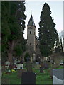
Christ Church, Pontblyddyn
The parish of Pontblyddyn was created on 23 May 1844, from the township of Hartsheath, and parts of the townships of Leeswood and Bistre, all of which had previously been in the parish of Mold.
The first church at Pontblyddyn was opened in 1836, initially as a chapel of ease within the parish of Mold. It was intended to serve the population of the industrialised area around Leeswood, and was built hastily and at minimum cost. The original building proved to be unsuitable; and eventually it was demolished.
A new church was erected on the same site, and consecrated in 1865.
Image: © Eirian Evans
Taken: 6 Jan 2007
0.07 miles
2
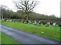
Cemetery at Pontblyddyn
Adjacent to Christ Church, this cemetery was adjudged the best kept cemetery in 1994.
Image: © Eirian Evans
Taken: 6 Jan 2007
0.07 miles