IMAGES TAKEN NEAR TO
Wrexham Road, MOLD, CH7 4HF
Introduction
This page details the photographs taken nearby to Wrexham Road, CH7 4HF by members of the Geograph project.
The Geograph project started in 2005 with the aim of publishing, organising and preserving representative images for every square kilometre of Great Britain, Ireland and the Isle of Man.

There are currently over 7.5m images from over14,400 individuals and you can help contribute to the project by visiting https://www.geograph.org.uk
Image Map
Images are licensed for reuse under creativecommons.org/licenses/by-sa/2.0
Notes
- Clicking on the map will re-center to the selected point.
- The higher the marker number, the further away the image location is from the centre of the postcode.
Image Listing (12 Images Found)
Images are licensed for reuse under creativecommons.org/licenses/by-sa/2.0
Image
Details
Distance
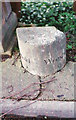
1
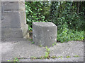
Old milestone by Leeswood Bridge
This old milestone is at the south-west corner of Leeswood Bridge. The left hand side is inscribed 'Mold 2' Image, and the right 'Wrexham 9' Image
Image: © John S Turner
Taken: 27 Jun 2010
0.22 miles
2
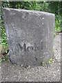
Old milestone by Leeswood Bridge - 'Mold 2'
This old milestone is at the south-west corner of Leeswood Bridge. This east face is inscribed 'Mold 2', and the other side 'Wrexham 9'. See also Image
Image: © John S Turner
Taken: 27 Jun 2010
0.22 miles
3
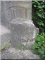
Old milestone by Leeswood Bridge - 'Wrexham 9'
This old milestone is at the south-west corner of Leeswood Bridge. This West face is inscribed 'Wrexham 9', and the other side 'Mold 2'. See also Image
Milestone Society National ID: FLT_MDWR02.
Image: © John S Turner
Taken: 27 Jun 2010
0.22 miles
4
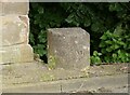
Old Milestone by the A541, Leeswood Bridge, Leeswood Parish
By the A541, in parish of Leeswood (Flintshire District), Leeswood Bridge, North West abutment, southbound carriageway.
Inscription reads:- : MOLD / 2 : : WREXHAM / 9 :
Surveyed
Milestone Society National ID: FLT_MDWR02.
Image: © Christopher Leather
Taken: 27 Jul 2024
0.22 miles
5
Old Milestone by the A541, Leeswood Bridge, Leeswood Parish
By the A541, in parish of Leeswood (Flintshire District), Leeswood Bridge, North West abutment, southbound carriageway.
Inscription reads:- : MOLD / 2 : : WREXHAM / 9 :
Surveyed
Milestone Society National ID: FLT_MDWR02.
Image: © Milestone Society
Taken: Unknown
0.22 miles
6
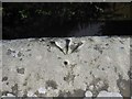
Pivot bench mark on Leeswood Bridge
This pivot bench mark is on top of the west parapet of the old Leeswood Bridge - see also Image The two lanes over the old bridge now carry east bound traffic only, whilst a new road has been built further west carrying the west bound traffic. There is an old milestone at the north west end of the bridge.
Image: © John S Turner
Taken: 28 Jun 2010
0.22 miles
7
Parapet of Leeswood Bridge and a bench mark.
Looking south east along the west parapet of old Leeswood Bridge, which spans the River Terrig. On top of the parapet there is a pivot bench mark. For a close up of the bench mark see Image The two lanes over the old bridge now carry east bound traffic only, whilst a new road has been built further west carrying the west bound traffic. There is an old milestone at the north west end of the bridge, which is behind the camera.
Image: © John S Turner
Taken: 28 Jun 2010
0.22 miles
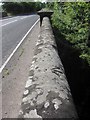
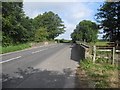
8
Leeswood Bridge
Looking across the A541 and Leeswood Bridge. This section of road is now one way only, eastbound (towards the camera), and west bound traffic has a new section of road that by-passes the old bridge.
Image: © John S Turner
Taken: 27 Jun 2010
0.22 miles
9
Leeswood Bridge and the A541
Looking across Leeswood Bridge, which carries the A541 east-bound traffic over the Afon Terrig/River Terrig. There is a pivot bench mark on the left-hand/south parapet Image
Image: © John S Turner
Taken: 28 Jun 2010
0.22 miles
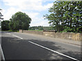
10
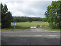
Gateway to Leeswood Old Hall
Looking across the west-bound carriageway of the A541 towards the gateway to Leeswood Old Hall. The east-bound carriageway is behind the camera.
Image: © John S Turner
Taken: 28 Jun 2010
0.23 miles