IMAGES TAKEN NEAR TO
Old School Lane, CH7 4FB
Introduction
This page details the photographs taken nearby to Old School Lane, CH7 4FB by members of the Geograph project.
The Geograph project started in 2005 with the aim of publishing, organising and preserving representative images for every square kilometre of Great Britain, Ireland and the Isle of Man.

There are currently over 7.5m images from over14,400 individuals and you can help contribute to the project by visiting https://www.geograph.org.uk
Image Map
Images are licensed for reuse under creativecommons.org/licenses/by-sa/2.0
Notes
- Clicking on the map will re-center to the selected point.
- The higher the marker number, the further away the image location is from the centre of the postcode.
Image Listing (7 Images Found)
Images are licensed for reuse under creativecommons.org/licenses/by-sa/2.0
Image
Details
Distance
1

Track to Bryn-y-Nant
Winding its way across the hill to a small farmstead on the far slope.
Image: © Alan Murray-Rust
Taken: 9 May 2019
0.09 miles
2

The Lot, Eryrys
Named simply 'Lot' on old OS maps.
Image: © Alan Murray-Rust
Taken: 9 May 2019
0.11 miles
3

Track to Llanerch Farm, with limekiln
The track to the left leads to a transmitting station. The kiln is shown in detail here http://www.geograph.org.uk/photo/6150638 .
Image: © Alan Murray-Rust
Taken: 9 May 2019
0.22 miles
4

Limekiln near Llanerch Farm
This has survived in unusually good condition for a small wayside kiln, and is Listed Grade II. The bowed front is a nice touch to what is otherwise quite a basic example.
Image: © Alan Murray-Rust
Taken: 9 May 2019
0.23 miles
5

Outcrop near Llanerch Farm
Featuring the limestone of the area.
Image: © Alan Murray-Rust
Taken: 9 May 2019
0.23 miles
6
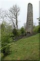
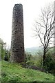
Chimney of the Nant or Westminster lead mine
This is associated with the engine house http://www.geograph.org.uk/photo/6150646 and is similarly Cornish in style. Originally there was a flue up the valley side, but this has disappeared. The chimney has been cleared of vegetation in recent years and is now well visible. Listed Grade II.
Image: © Alan Murray-Rust
Taken: 9 May 2019
0.25 miles
7
Chimney of the Nant or Westminster lead mine
This is associated with the engine house http://www.geograph.org.uk/photo/6150646 and is similarly Cornish in style. Originally there was a flue up the valley side, but this has disappeared. The chimney has been cleared of vegetation in recent years and is now well visible. Listed Grade II.
Image: © Alan Murray-Rust
Taken: 9 May 2019
0.25 miles