IMAGES TAKEN NEAR TO
Pentre Bach, MOLD, CH7 4EQ
Introduction
This page details the photographs taken nearby to Pentre Bach, CH7 4EQ by members of the Geograph project.
The Geograph project started in 2005 with the aim of publishing, organising and preserving representative images for every square kilometre of Great Britain, Ireland and the Isle of Man.

There are currently over 7.5m images from over14,400 individuals and you can help contribute to the project by visiting https://www.geograph.org.uk
Image Map
Images are licensed for reuse under creativecommons.org/licenses/by-sa/2.0
Notes
- Clicking on the map will re-center to the selected point.
- The higher the marker number, the further away the image location is from the centre of the postcode.
Image Listing (7 Images Found)
Images are licensed for reuse under creativecommons.org/licenses/by-sa/2.0
Image
Details
Distance
1
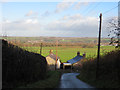
View from Ffordd Pentre Bach
Looking south east down Ffordd Pentre Bach the town of Mold can be seen low down on the left. In the distance, merging along the skyline, Mynydd Isa is to the left, and Buckley right. At the bottom of the hill, the house on the right has an Ordnance Survey bench mark on the south west corner - Image
Image: © John S Turner
Taken: 4 Dec 2013
0.03 miles
2
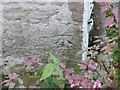
Bench mark on The Cuppins, Ffordd Pentre Bach
This bench mark is on the south west corner of The Cuppins and is visible from Ffordd Pentre Bach, the road that passes the west end of the house. For details of the mark see: http://www.bench-marks.org.uk/bm53574
Image: © John S Turner
Taken: 4 Dec 2013
0.03 miles
3
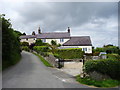
Ffordd Las
Houses at the junction of Ffordd Pentre Bach and Swan Lane, east of Gwernymynydd.
Image: © Eirian Evans
Taken: 14 Aug 2011
0.03 miles
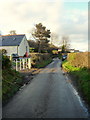

6
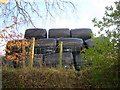
Silage heap towering over Ffordd Las, a sunken lane near Nercwys
Image: © Aaron Thomas
Taken: 28 Dec 2006
0.24 miles
7
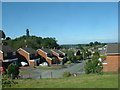
Gwernymynydd
Looking north, over the Dee Estuary and the Wirral. Using the naked eye, Liverpool [Anglican] Cathedral is visible from this point.
Image: © David Medcalf
Taken: 8 Aug 2005
0.25 miles