IMAGES TAKEN NEAR TO
Nercwys, MOLD, CH7 4EB
Introduction
This page details the photographs taken nearby to CH7 4EB by members of the Geograph project.
The Geograph project started in 2005 with the aim of publishing, organising and preserving representative images for every square kilometre of Great Britain, Ireland and the Isle of Man.

There are currently over 7.5m images from over14,400 individuals and you can help contribute to the project by visiting https://www.geograph.org.uk
Image Map
Images are licensed for reuse under creativecommons.org/licenses/by-sa/2.0
Notes
- Clicking on the map will re-center to the selected point.
- The higher the marker number, the further away the image location is from the centre of the postcode.
Image Listing (13 Images Found)
Images are licensed for reuse under creativecommons.org/licenses/by-sa/2.0
Image
Details
Distance
1
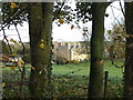
Nercwys Hall
A picture of Nercwys Hall taken from the nearby road. The Hall is on private land and is difficult to photograph without trespassing.
Image: © Aaron Thomas
Taken: 19 Nov 2006
0.02 miles
2
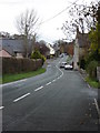
Ffordd Pentre, Nercwys
The main drag through Nercwys village.
Image: © Aaron Thomas
Taken: 19 Nov 2006
0.12 miles
4
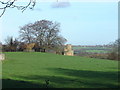
Disused railway trackbed in Nercwys
This disused railway trackbed leads towards Nercwys Hall, and once served a coalmine railway.
Image: © Aaron Thomas
Taken: 19 Nov 2006
0.17 miles
5

Disused railway trackbed in Nercwys.
This disused railway trackbed leads towards Nercwys Hall, and once served a coalmine railway. Beyond the road can be seen the gates leading to Nercwys Hall.
Image: © Aaron Thomas
Taken: 19 Nov 2006
0.17 miles
6
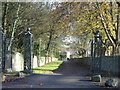
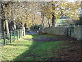
Nercwys Hall driveway
This is the left-hand driveway leading to Nercwys Hall.
Image: © Aaron Thomas
Taken: 19 Nov 2006
0.17 miles
7
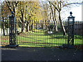
Driveway leading to Nercwys Hall
This is the right-hand driveway leading to Nercwys Hall. Evidently it is less used than the left-hand driveway.
Image: © Aaron Thomas
Taken: 19 Nov 2006
0.17 miles
8
Ffordd y Pentre, Nercwys
Looking south along Ffordd y Pentre from its junction with Ffordd Llewelyn. The nearest gatepost on the right has an Ordnance Survey bench mark: Image
Image: © John S Turner
Taken: 2 Dec 2013
0.19 miles
9
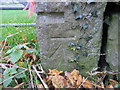
Bench mark alongside Ffordd y Pentre
This cut bench mark is on the field gatepost at the south west corner of the junction of Ffordd y Pentre and Ffordd Llewelyn. Immediately above the cut mark is the remains of a quarry blasting hole. See also Image For details of the cut mark see: http://www.bench-marks.org.uk/bm53020
Image: © John S Turner
Taken: 2 Dec 2013
0.19 miles
10
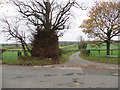
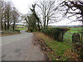
The Ffordd y Pentre and Ffordd Llewelyn junction, Nercwys
Looking across Ffordd y Pentre towards Ffordd Llewelyn outside the village of Nercwys. A stone gatepost for the field gate at the left of the junction has a cut bench mark: Image
Image: © John S Turner
Taken: 2 Dec 2013
0.19 miles