IMAGES TAKEN NEAR TO
Ffordd Maeshafn, Maeshafn, MOLD, CH7 4DW
Introduction
This page details the photographs taken nearby to Ffordd Maeshafn, Maeshafn, CH7 4DW by members of the Geograph project.
The Geograph project started in 2005 with the aim of publishing, organising and preserving representative images for every square kilometre of Great Britain, Ireland and the Isle of Man.

There are currently over 7.5m images from over14,400 individuals and you can help contribute to the project by visiting https://www.geograph.org.uk
Image Map
Images are licensed for reuse under creativecommons.org/licenses/by-sa/2.0
Notes
- Clicking on the map will re-center to the selected point.
- The higher the marker number, the further away the image location is from the centre of the postcode.
Image Listing (9 Images Found)
Images are licensed for reuse under creativecommons.org/licenses/by-sa/2.0
Image
Details
Distance
1
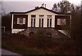
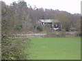
front of Maeshafn YHA
June 1980 - virtually unchanged from its construction in 1931. Contrast with the Google Streetscene post-2004 closure image.
Image: © John Lawson
Taken: Unknown
0.12 miles
2
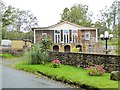
Former Youth Hostel at Maeshafn
This unusual building was the first purpose-built youth hostel in the country (indeed there were very few purpose-built hostels). Known as the Holt Hostel in honour of the Holt shipping family of Liverpool who funded its construction. The building was designed by the architect Clough Williams-Ellis (1883-1978) who also designed Portmeirion village. Grade 2 listed on account of its historical and architectural interest.
In early years a popular weekend hostel as it was within easy cycling distance of Merseyside. Latterly, as hostellers acquired cars and could readily get to Snowdonia for weekends, the usage of the hostel declined. I spent a week here as volunteer warden in 1997 towards the end of its existence as a hostel. It closed permanently in the winter of 2004/5.
Now privately owned and has undergone substantial refurbishment. Compare with Image
Image: © Oliver Dixon
Taken: 17 Sep 2017
0.12 miles
3
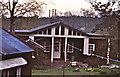
Maeshafn YHA from garden
June 1980 view of rear.
Image: © John Lawson
Taken: Unknown
0.14 miles
4
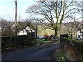
View towards Maeshafn from the Nercwys to Eryrys Road
Image: © Eirian Evans
Taken: 24 Feb 2011
0.15 miles
5
Maeshafn Youth Hostel
This was the YHA's first purpose built hostel, built in the 1930's. It has now been closed.
Image: © Eirian Evans
Taken: 17 Apr 2006
0.16 miles
6
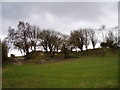
Hawthorn Trees on Moel Findeg
Moel Findeg is a Local Nature Reserve. Moel Findeg was acquired by Denbighshire County Council in 1999, with the help of a Heritage Lottery Fund grant and support of the Countryside Council for Wales. Local people, through the Friends of Moel Findeg Charitable Trust, also provided significant help to bring the site into public ownership and to save the mountain from being quarried.
Image: © Eirian Evans
Taken: 17 Apr 2006
0.16 miles
8
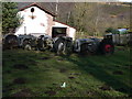
Old Massey Ferguson tractors at Tir-y-Coed Farm
Image: © Eirian Evans
Taken: 24 Feb 2011
0.19 miles
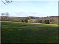
9
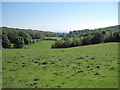
Farmland near Maeshafn
Most of the farmland around Maeshafn is, perhaps inevitably, predominantly sheep based.
Image: © David Quinn
Taken: 30 May 2009
0.19 miles