IMAGES TAKEN NEAR TO
Eryrys Road, MOLD, CH7 4BU
Introduction
This page details the photographs taken nearby to Eryrys Road, CH7 4BU by members of the Geograph project.
The Geograph project started in 2005 with the aim of publishing, organising and preserving representative images for every square kilometre of Great Britain, Ireland and the Isle of Man.

There are currently over 7.5m images from over14,400 individuals and you can help contribute to the project by visiting https://www.geograph.org.uk
Image Map
Images are licensed for reuse under creativecommons.org/licenses/by-sa/2.0
Notes
- Clicking on the map will re-center to the selected point.
- The higher the marker number, the further away the image location is from the centre of the postcode.
Image Listing (3 Images Found)
Images are licensed for reuse under creativecommons.org/licenses/by-sa/2.0
Image
Details
Distance
1
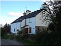
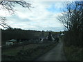
Voel-las Farm
The farmhouse at Voel-las Farm. The nearest door to the photographer enters what appears to be a separate dwelling which has been converted from the original farmhouse building.
Image: © Aaron Thomas
Taken: 30 Oct 2006
0.03 miles