IMAGES TAKEN NEAR TO
Pentre, Ffordd Y Rhos, MOLD, CH7 4BQ
Introduction
This page details the photographs taken nearby to Pentre, Ffordd Y Rhos, CH7 4BQ by members of the Geograph project.
The Geograph project started in 2005 with the aim of publishing, organising and preserving representative images for every square kilometre of Great Britain, Ireland and the Isle of Man.

There are currently over 7.5m images from over14,400 individuals and you can help contribute to the project by visiting https://www.geograph.org.uk
Image Map
Images are licensed for reuse under creativecommons.org/licenses/by-sa/2.0
Notes
- Clicking on the map will re-center to the selected point.
- The higher the marker number, the further away the image location is from the centre of the postcode.
Image Listing (3 Images Found)
Images are licensed for reuse under creativecommons.org/licenses/by-sa/2.0
Image
Details
Distance
1
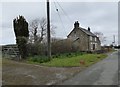
Cottage on the junction of Ffordd y Rhos and Pant y Ffridd
Previously two cottages which have been converted into one.
Image: © Eirian Evans
Taken: 10 Mar 2016
0.14 miles
2
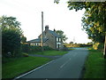
Pant-y-ffordd cottage
"Pant-y-ffordd" ["Valley road"] is on the sign outside the cottage, but it may refer just to the lane. Looking north.
Image: © David Medcalf
Taken: 29 Aug 2006
0.16 miles
3
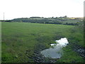
Farmland near the Afon Terrig
The river [Afon Terrig] is out of sight, in the valley beyond the field. Looking south west.
Image: © David Medcalf
Taken: 29 Aug 2006
0.22 miles