IMAGES TAKEN NEAR TO
Ffordd Llanarmon, MOLD, CH7 4BP
Introduction
This page details the photographs taken nearby to Ffordd Llanarmon, CH7 4BP by members of the Geograph project.
The Geograph project started in 2005 with the aim of publishing, organising and preserving representative images for every square kilometre of Great Britain, Ireland and the Isle of Man.

There are currently over 7.5m images from over14,400 individuals and you can help contribute to the project by visiting https://www.geograph.org.uk
Image Map
Images are licensed for reuse under creativecommons.org/licenses/by-sa/2.0
Notes
- Clicking on the map will re-center to the selected point.
- The higher the marker number, the further away the image location is from the centre of the postcode.
Image Listing (8 Images Found)
Images are licensed for reuse under creativecommons.org/licenses/by-sa/2.0
Image
Details
Distance
1
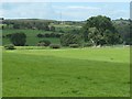
Tree on a field boundary near Rhyd y Ceirw Farm
To the west of the A5104.
Image: © Christine Johnstone
Taken: 18 Aug 2019
0.11 miles
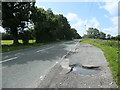
2
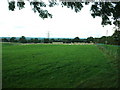
Farmland by the A5104
Looking north east.
Image: © David Medcalf
Taken: 29 Aug 2006
0.13 miles
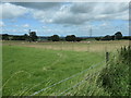
3
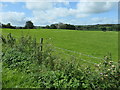
Farmland east of Rhyd y Ceirw
Bounded on two sides by the A5104 and Ffordd Llanarmon.
Image: © Christine Johnstone
Taken: 18 Aug 2019
0.15 miles
6
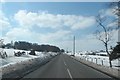
The A5104 cuts through a snowy landscape
Image: © Anthony Parkes
Taken: 29 Mar 2013
0.20 miles
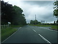
7
A5104 heading south
Between Treuddyn and Rhydtalog.
Image: © Christine Johnstone
Taken: 18 Aug 2019
0.20 miles
8
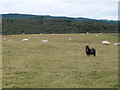
Sheepfield, east of Rhyd y Ceirw
On the west side of the A5104.
Image: © Christine Johnstone
Taken: 18 Aug 2019
0.20 miles