IMAGES TAKEN NEAR TO
Mynydd Du Road, MOLD, CH7 4BL
Introduction
This page details the photographs taken nearby to Mynydd Du Road, CH7 4BL by members of the Geograph project.
The Geograph project started in 2005 with the aim of publishing, organising and preserving representative images for every square kilometre of Great Britain, Ireland and the Isle of Man.

There are currently over 7.5m images from over14,400 individuals and you can help contribute to the project by visiting https://www.geograph.org.uk
Image Map
Images are licensed for reuse under creativecommons.org/licenses/by-sa/2.0
Notes
- Clicking on the map will re-center to the selected point.
- The higher the marker number, the further away the image location is from the centre of the postcode.
Image Listing (3 Images Found)
Images are licensed for reuse under creativecommons.org/licenses/by-sa/2.0
Image
Details
Distance
1
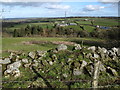
Across grazing land to Tryddyn-fechan Farm
The Afon Terrig runs through the trees in between. In the far distance on the left you can see across The Wirral to Liverpool Cathedral.
Image: © Maggie Cox
Taken: 16 Feb 2014
0.14 miles
2
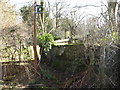
Stone stile and gate for footpaths
Heading east and south west
Image: © Maggie Cox
Taken: 16 Feb 2014
0.22 miles
3
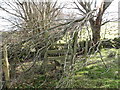
Some stiles are not easy to negotiate!
This footpath stile had been blocked by a branch fallen in the recent storm
Image: © Maggie Cox
Taken: 16 Feb 2014
0.23 miles