IMAGES TAKEN NEAR TO
Trem Y Dref, MOLD, CH7 4AN
Introduction
This page details the photographs taken nearby to Trem Y Dref, CH7 4AN by members of the Geograph project.
The Geograph project started in 2005 with the aim of publishing, organising and preserving representative images for every square kilometre of Great Britain, Ireland and the Isle of Man.

There are currently over 7.5m images from over14,400 individuals and you can help contribute to the project by visiting https://www.geograph.org.uk
Image Map
Images are licensed for reuse under creativecommons.org/licenses/by-sa/2.0
Notes
- Clicking on the map will re-center to the selected point.
- The higher the marker number, the further away the image location is from the centre of the postcode.
Image Listing (5 Images Found)
Images are licensed for reuse under creativecommons.org/licenses/by-sa/2.0
Image
Details
Distance
1
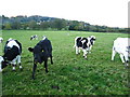
Grazing fields north of Tros-y-wern Farm
On a footpath heading north for Hendy Road in the company of some frisky young cattle
Image: © Maggie Cox
Taken: 10 Nov 2013
0.10 miles
2
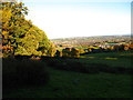
From a footpath across fields by Hafod Road
In the near distance is the town of Mold and the far distance is Buckley town. In the far right distance you can see the Padeswood Cement factory
Image: © Maggie Cox
Taken: 10 Nov 2013
0.15 miles
3
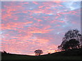
The setting sun from Ffordd Hafod/Hafod Road
The setting sun highlights the bare trees above Ffordd Hafod/Hafod Road, Gwernymynydd. The popular Plas Hafod Country House Hotel and Restaurant is set in the woodland to the right. Image https://plashafod.co.uk/
Image: © John S Turner
Taken: 30 Nov 2013
0.19 miles