IMAGES TAKEN NEAR TO
Linthorpe Gardens, BUCKLEY, CH7 3HT
Introduction
This page details the photographs taken nearby to Linthorpe Gardens, CH7 3HT by members of the Geograph project.
The Geograph project started in 2005 with the aim of publishing, organising and preserving representative images for every square kilometre of Great Britain, Ireland and the Isle of Man.

There are currently over 7.5m images from over14,400 individuals and you can help contribute to the project by visiting https://www.geograph.org.uk
Image Map
Images are licensed for reuse under creativecommons.org/licenses/by-sa/2.0
Notes
- Clicking on the map will re-center to the selected point.
- The higher the marker number, the further away the image location is from the centre of the postcode.
Image Listing (74 Images Found)
Images are licensed for reuse under creativecommons.org/licenses/by-sa/2.0
Image
Details
Distance
1
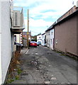
Daisy Hill Road, Buckley
From the north side of the A549 Brunswick Road, Daisy Hill Road leads to Linthorpe Gardens.
Image: © Jaggery
Taken: 12 Oct 2019
0.06 miles
2
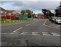
North along Church Road, Buckley
The B5128 Church Road viewed across the A549.
Image: © Jaggery
Taken: 12 Oct 2019
0.07 miles
3
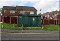
Church Road gas installation, Buckley
Viewed across the B5128 Church Road. The large green cabinet is a Wales & West Utilities gas installation.
Image: © Jaggery
Taken: 12 Oct 2019
0.08 miles
4
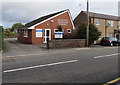
Brunswick Veterinary Surgery, Buckley
At 121-123 Brunswick Road on the north side of the A549.
Image: © Jaggery
Taken: 12 Oct 2019
0.08 miles
5
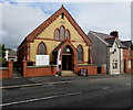
Ebenezer Baptist Church, Buckley
Viewed across the A549 Brunswick Road on October 12th 2019.
The board on the pavement near the entrance shows
HARVEST CELEBRATION 12 & 13 OCTOBER.
Image: © Jaggery
Taken: 12 Oct 2019
0.08 miles
6
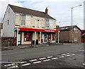
Bargain Booze, 121 Brunswick Road, Buckley
On the corner of Daisy Hill Road.
Image: © Jaggery
Taken: 12 Oct 2019
0.09 miles
7
Queen Elizabeth II postbox in a Brunswick Road wall, Buckley
On the south side of the A549. https://www.geograph.org.uk/photo/6296133 to a closer view.
Image: © Jaggery
Taken: 12 Oct 2019
0.09 miles
8
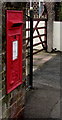
Queen Elizabeth II postbox, Brunswick Road, Buckley
Located here. https://www.geograph.org.uk/photo/6296132
Image: © Jaggery
Taken: 12 Oct 2019
0.09 miles
9
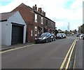
Cars and houses, Church Road, Buckley
The B5128 Church Road viewed from the corner of the A549 Chester Road.
Image: © Jaggery
Taken: 12 Oct 2019
0.09 miles
10
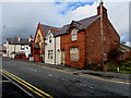
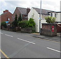
Derelict corner house, Brunswick Road, Buckley
In October 2019 boards protect the ground floor window of the house on the corner of Church Road.
Image: © Jaggery
Taken: 12 Oct 2019
0.09 miles