1
Memorial in Coronation Gardens, Buckley
Dedicated to the memory of members of Bistre Methodist Chapel, Spon Green, Buckley, who fell in the Great War and the Second World War.
Image: © Jaggery
Taken: 12 Oct 2019
0.05 miles
2
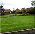
Coronation Gardens, Buckley
Set back from the north side of the A549 Chester Road. A Buckley Town Council information notice records that Coronation Gardens were laid out in 1953 on land provided by a local family to commemorate the coronation of Queen Elizabeth II. The gardens were reopened on April 1st 2010 after complete refurbishment.
Image: © Jaggery
Taken: 12 Oct 2019
0.05 miles
3
Buckley Town Trail
This part of the trail is north of the A549 Chester Road in the east of Buckley.
An English/Welsh trail direction sign https://www.geograph.org.uk/photo/6300626 is near the camera.
Image: © Jaggery
Taken: 12 Oct 2019
0.07 miles
4
Row of brick houses, Chester Road, Buckley
On the north side of the A549 Chester Road.
Image: © Jaggery
Taken: 12 Oct 2019
0.07 miles
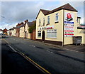
5
Shamrock in Buckley
Pub at 46 Chester Road.
Image: © Jaggery
Taken: 12 Oct 2019
0.07 miles
6
Shamrock pub name sign, Buckley
Hanging from a wall bracket here. https://www.geograph.org.uk/photo/6297218
Image: © Jaggery
Taken: 12 Oct 2019
0.07 miles
7
Buckley Town Trail direction sign
The brown sign alongside the A549 Chester Road in the east of Buckley points right (north) along this https://www.geograph.org.uk/photo/6300631 public footpath. The text is also in Welsh.
Image: © Jaggery
Taken: 12 Oct 2019
0.08 miles
8
Mei Mei Buckley
Mei Mei Chinese cuisine takeaway is at 33 Chester Road, Buckley.
Image: © Jaggery
Taken: 12 Oct 2019
0.08 miles
9
Lux? Salon in Buckley
Hair and beauty salon in Crown Vaults Building, Chester Road.
The Shamrock pub is on the left.
Image: © Jaggery
Taken: 12 Oct 2019
0.08 miles
10
Chester Road flats, Buckley
Three-storey block on flats on the south side of the A549 Chester Road.
A sign near the lamppost shows 46-68 Chester Road.
Image: © Jaggery
Taken: 12 Oct 2019
0.08 miles


