IMAGES TAKEN NEAR TO
Burntwood Road, BUCKLEY, CH7 3EN
Introduction
This page details the photographs taken nearby to Burntwood Road, CH7 3EN by members of the Geograph project.
The Geograph project started in 2005 with the aim of publishing, organising and preserving representative images for every square kilometre of Great Britain, Ireland and the Isle of Man.

There are currently over 7.5m images from over14,400 individuals and you can help contribute to the project by visiting https://www.geograph.org.uk
Image Map
Images are licensed for reuse under creativecommons.org/licenses/by-sa/2.0
Notes
- Clicking on the map will re-center to the selected point.
- The higher the marker number, the further away the image location is from the centre of the postcode.
Image Listing (7 Images Found)
Images are licensed for reuse under creativecommons.org/licenses/by-sa/2.0
Image
Details
Distance
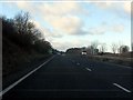
1
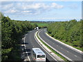
A55(T) Expressway
A view looking west from the Wood Lane bridge over the A55(T) North Wales Expressway.
Image: © Phil Williams
Taken: 26 Sep 2006
0.07 miles
2
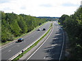
A55(T) expressway
A view looking east from the Wood Lane bridge over the A55(T) North Wales Expressway.
Image: © Phil Williams
Taken: 26 Sep 2006
0.07 miles
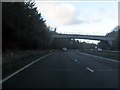
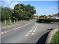
3
Burntwood Road
A view looking northeast along Burntwood Road at the bridge where it crosses the A55(T) dual carriageway. The road becomes Wood Lane on the other side of the bridge. The Cheshire Plain can be seen on the horizon.
Image: © Phil Williams
Taken: 26 Sep 2006
0.07 miles
5
Wood Lane
A view looking northeast along Wood Lane, at the junction with Woodland Drive.
Image: © Phil Williams
Taken: 26 Sep 2006
0.15 miles
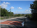
7
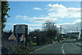
Burntwood Road at Drury village boundary
Image: © Colin Pyle
Taken: 17 Feb 2015
0.24 miles