IMAGES TAKEN NEAR TO
Chester Road, BUCKLEY, CH7 3AJ
Introduction
This page details the photographs taken nearby to Chester Road, CH7 3AJ by members of the Geograph project.
The Geograph project started in 2005 with the aim of publishing, organising and preserving representative images for every square kilometre of Great Britain, Ireland and the Isle of Man.

There are currently over 7.5m images from over14,400 individuals and you can help contribute to the project by visiting https://www.geograph.org.uk
Image Map
Images are licensed for reuse under creativecommons.org/licenses/by-sa/2.0
Notes
- Clicking on the map will re-center to the selected point.
- The higher the marker number, the further away the image location is from the centre of the postcode.
Image Listing (65 Images Found)
Images are licensed for reuse under creativecommons.org/licenses/by-sa/2.0
Image
Details
Distance
1
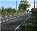
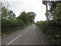
A549 Dirty Mile east of Buckley, Flintshire
The A549 behind the camera is Chester Road.
Here, beyond the Station Road/Drury New Road crossroads, the A549 is Dirty Mile.
Image: © Jaggery
Taken: 12 Oct 2019
0.02 miles
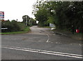
2
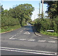
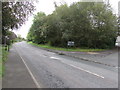
Junction of Drury New Road and the A549, Buckley
Ahead along Drury New Road for the village of Drury, Flintshire.
Image: © Jaggery
Taken: 12 Oct 2019
0.05 miles
3
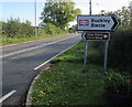
Buckley railway station direction sign
On the corner of the A549 and Station Road. Buckley is Bwcle in Welsh.
Image: © Jaggery
Taken: 12 Oct 2019
0.05 miles
4
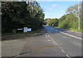
Junction of Station Road and Chester Road in the east of Buckley
From the left, Station Road from Buckley railway station joins the A549 Chester Road.
Image: © Jaggery
Taken: 12 Oct 2019
0.06 miles
5
South along Station Road, Buckley
From the A549 Chester Road, Station Road leads to Buckley railway station https://www.geograph.org.uk/photo/6298888 about 300 metres ahead.
Image: © Jaggery
Taken: 12 Oct 2019
0.06 miles
6
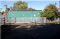
Keep Clear - Gate in constant use, Station Road, Buckley
At the entrance to an industrial site on the west side of Station Road.
Image: © Jaggery
Taken: 12 Oct 2019
0.07 miles
7
Station Road towards Buckley station
This way for Buckley railway station https://www.geograph.org.uk/photo/6298888 on the Borderlands Line.
Image: © Jaggery
Taken: 12 Oct 2019
0.09 miles
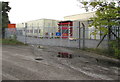
8
Large green cabinet, Station Road, Buckley
The cabinet is an SP Manweb electricity substation.
Its identifier is BUCKLEY 07/2963/002E
Image: © Jaggery
Taken: 12 Oct 2019
0.11 miles
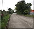
9
Drury New Road, Flintshire
From the A549 in Buckley behind the camera towards the village of Drury, Flintshire
Image: © Jaggery
Taken: 12 Oct 2019
0.11 miles
10
East along the A549 Chester Road, Buckley
This way for Buckley railway station. The junction on the right is the entrance road https://www.geograph.org.uk/photo/6304574 to Natural Resources Wales, Buckley.
Image: © Jaggery
Taken: 12 Oct 2019
0.12 miles