IMAGES TAKEN NEAR TO
Mold Road, BUCKLEY, CH7 2NT
Introduction
This page details the photographs taken nearby to Mold Road, CH7 2NT by members of the Geograph project.
The Geograph project started in 2005 with the aim of publishing, organising and preserving representative images for every square kilometre of Great Britain, Ireland and the Isle of Man.

There are currently over 7.5m images from over14,400 individuals and you can help contribute to the project by visiting https://www.geograph.org.uk
Image Map
Images are licensed for reuse under creativecommons.org/licenses/by-sa/2.0
Notes
- Clicking on the map will re-center to the selected point.
- The higher the marker number, the further away the image location is from the centre of the postcode.
Image Listing (6 Images Found)
Images are licensed for reuse under creativecommons.org/licenses/by-sa/2.0
Image
Details
Distance
1
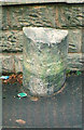
Old Milestone by the A549 in Buckley
Milestone by the A549, in parish of Buckley (Flintshire District), West of Springfield Drive, Prenbrigog, in pavement, back to block wall, South side of road.
Inscription once read:-
: MOLD / 2 : : LANE END / 1¼ :
Surveyed
Milestone Society National ID: FLT_MDBK02
Image: © Milestone Society
Taken: Unknown
0.05 miles
2
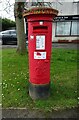
George VI postbox on Stanley Road, Buckley
Postbox No. CH7 108.
Image: © JThomas
Taken: 19 Apr 2024
0.09 miles
4
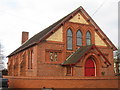
Former Wesleyan Chapel, Mold Road
The former Wesleyan Chapel on Mold Road is now converted into a private residence.
Image: © Sue Adair
Taken: 21 Feb 2009
0.19 miles
5
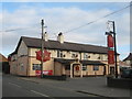
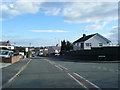
The White Lion
The White Lion on Mold Road, Buckley.
Image: © Sue Adair
Taken: 21 Feb 2009
0.20 miles
6
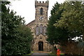
Emmanuel Church, Bistre
Beside the A494 Buckley-Mold road
Image: © David Long
Taken: 7 Mar 2006
0.25 miles