IMAGES TAKEN NEAR TO
Lambs Lane, BUCKLEY, CH7 2HW
Introduction
This page details the photographs taken nearby to Lambs Lane, CH7 2HW by members of the Geograph project.
The Geograph project started in 2005 with the aim of publishing, organising and preserving representative images for every square kilometre of Great Britain, Ireland and the Isle of Man.

There are currently over 7.5m images from over14,400 individuals and you can help contribute to the project by visiting https://www.geograph.org.uk
Image Map
Images are licensed for reuse under creativecommons.org/licenses/by-sa/2.0
Notes
- Clicking on the map will re-center to the selected point.
- The higher the marker number, the further away the image location is from the centre of the postcode.
Image Listing (89 Images Found)
Images are licensed for reuse under creativecommons.org/licenses/by-sa/2.0
Image
Details
Distance
1
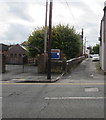
Lamb's Lane, Buckley
Dead-end lane on the south side of Chester Road. All Saints Church is on the left.
Image: © Jaggery
Taken: 12 Oct 2019
0.01 miles
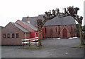
2
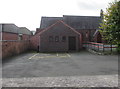
North side of All Saints Church, Buckley
The church on the corner of Chester Road and Lamb's Lane is in the Church in Wales Parish of Bistre in the Diocese of St Asaph.
Image: © Jaggery
Taken: 12 Oct 2019
0.01 miles
3
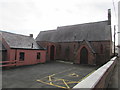
Yellow-marked parking area outside All Saints Church, Buckley
The marked area is for the vehicle of a Blue Badge holder. The church on the corner of Chester Road and Lamb's Lane is in the Church in Wales Parish of Bistre in the Diocese of St Asaph.
Image: © Jaggery
Taken: 12 Oct 2019
0.02 miles
5
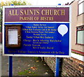
All Saints Church information board, Buckley
The board on the corner of Chester Road and Lamb's Lane is on the north side of the church. https://www.geograph.org.uk/photo/6298302
Viewed in October 2019.
Image: © Jaggery
Taken: 12 Oct 2019
0.02 miles
6
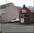
Former upholstery shop, Chester Road, Buckley
A TO LET board is on the wall of the shop in October 2019.
Image: © Jaggery
Taken: 12 Oct 2019
0.02 miles
7
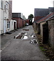
Puddles on a Buckley side road
On the south side of the A549 Chester Road in Buckley on October 12th 2019.
Image: © Jaggery
Taken: 12 Oct 2019
0.02 miles
8
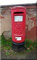
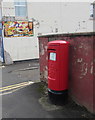
Elizabeth II postbox on Chester Road, Buckley
Postbox No. CH7 111.
Image: © JThomas
Taken: 19 Apr 2024
0.03 miles
9
Queen Elizabeth II pillarbox, Chester Road, Buckley
On the right here. https://www.geograph.org.uk/photo/6298352
Image: © Jaggery
Taken: 12 Oct 2019
0.03 miles
10
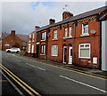
Row of brick houses, Chester Road, Buckley
On the north side of the A549 Chester Road.
Image: © Jaggery
Taken: 12 Oct 2019
0.03 miles