IMAGES TAKEN NEAR TO
Coppafield Close, BUCKLEY, CH7 2AH
Introduction
This page details the photographs taken nearby to Coppafield Close, CH7 2AH by members of the Geograph project.
The Geograph project started in 2005 with the aim of publishing, organising and preserving representative images for every square kilometre of Great Britain, Ireland and the Isle of Man.

There are currently over 7.5m images from over14,400 individuals and you can help contribute to the project by visiting https://www.geograph.org.uk
Image Map
Images are licensed for reuse under creativecommons.org/licenses/by-sa/2.0
Notes
- Clicking on the map will re-center to the selected point.
- The higher the marker number, the further away the image location is from the centre of the postcode.
Image Listing (87 Images Found)
Images are licensed for reuse under creativecommons.org/licenses/by-sa/2.0
Image
Details
Distance
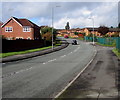
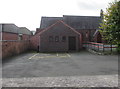
2
Lamb's Lane, Buckley
Dead-end lane on the south side of Chester Road. All Saints Church is on the left.
Image: © Jaggery
Taken: 12 Oct 2019
0.05 miles
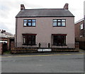
3
Two white front doors, Brunswick Road, Buckley
On the south side of the A549 opposite the B5128 Church Road.
Image: © Jaggery
Taken: 12 Oct 2019
0.05 miles
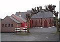
4
North side of All Saints Church, Buckley
The church on the corner of Chester Road and Lamb's Lane is in the Church in Wales Parish of Bistre in the Diocese of St Asaph.
Image: © Jaggery
Taken: 12 Oct 2019
0.06 miles
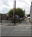
5
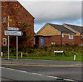
Direction signs on the corner of the A549 and B5128, Buckley
Pointing right along the B5128 Church Road towards industrial estates and Ewloe.
A small yellow sign points towards Victoria Court.
Image: © Jaggery
Taken: 12 Oct 2019
0.06 miles
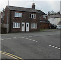
6
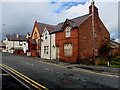
Derelict corner house, Brunswick Road, Buckley
In October 2019 boards protect the ground floor window of the house on the corner of Church Road.
Image: © Jaggery
Taken: 12 Oct 2019
0.06 miles
7
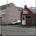
Former upholstery shop, Chester Road, Buckley
A TO LET board is on the wall of the shop in October 2019.
Image: © Jaggery
Taken: 12 Oct 2019
0.06 miles
8
A549 direction signs facing Church Road, Buckley
Left for Dobshill, right for Mold (Yr Wyddgrug in Welsh).
Image: © Jaggery
Taken: 12 Oct 2019
0.06 miles
9
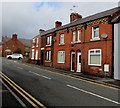
Row of brick houses, Chester Road, Buckley
On the north side of the A549 Chester Road.
Image: © Jaggery
Taken: 12 Oct 2019
0.06 miles