
IMAGES TAKEN NEAR TO
Glan Aber, Brook Street, MOLD, CH7 1PJ
Introduction
This page details the photographs taken nearby to Glan Aber, Brook Street, CH7 1PJ by members of the Geograph project.
The Geograph project started in 2005 with the aim of publishing, organising and preserving representative images for every square kilometre of Great Britain, Ireland and the Isle of Man.

There are currently over 7.5m images from over14,400 individuals and you can help contribute to the project by visiting https://www.geograph.org.uk
Image Map
Images are licensed for reuse under creativecommons.org/licenses/by-sa/2.0
Notes
- Clicking on the map will re-center to the selected point.
- The higher the marker number, the further away the image location is from the centre of the postcode.
Image Listing (61 Images Found)
Images are licensed for reuse under creativecommons.org/licenses/by-sa/2.0
Image
Details
Distance
1
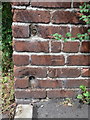
Bench mark in Brook Street, Mold
This bench mark is at the end of an alley just off Brook Street, Mold. See also: Image
Image: © John S Turner
Taken: 8 Jul 2014
0.02 miles
2
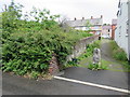
Alley off Brook Street, Mold
This alley links Brook Street, and Gladstone Street in Mold. There is a bench mark cut into the brickwork nearest the camera, facing across the alley. See: Image
Image: © John S Turner
Taken: 8 Jul 2014
0.02 miles
4
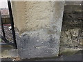
Bench mark on Methodist Church gatepost, Wrexham St
This weathered cut mark is on the right hand gatepost of the Methodist Church in Wrexham Street, Mold.
Image: © John S Turner
Taken: 8 Jul 2014
0.08 miles
5

Ordnance Survey Cut Mark
This OS cut mark can be found on the gatepost of the Methodist Chapel, Wrexham Street. It marks a point 109.531m above mean sea level
Image: © Adrian Dust
Taken: 10 Nov 2025
0.08 miles
6
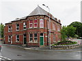
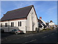
Stylish building in Wrexham Street, Mold
This stylish building is on the corner of Wrexham Street and Alexandra Road, and Old-maps records that a building at this location was once a public house. There is an Ordnance Survey bench mark just to the left of the green door. See: Image
Image: © John S Turner
Taken: 8 Jul 2014
0.08 miles
7
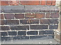
Bench mark in Wrexham Street, Mold
This bench mark is near the south west corner of a stylish building on the corner of Wrexham Street and Alexandra Road. The building was once a public house but the mark only dates to 1958 so the Ordnance Survey only record it as a 'building'. See: Image
Image: © John S Turner
Taken: 8 Jul 2014
0.09 miles
8

Ordnance Survey Cut Mark
This OS cut mark can be found on The Old Bowling Green Hotel. It marks a point 107.817m above mean sea level
Image: © Adrian Dust
Taken: 10 Nov 2025
0.09 miles
9
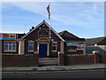
Mold Ex-Servicemen's Club
On the west side of Wrexham Street, the club was opened in 1923 by the Prince of Wales.
Image: © Eirian Evans
Taken: 24 Feb 2011
0.09 miles
10
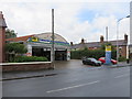
ATS Euromaster, Wrexham Road, Mold
A long standing tyre, and car and van related services business alongside Wrexham Road, Mold.
Image: © John S Turner
Taken: 8 Jul 2014
0.13 miles